Larrybane, Game of Thrones Location, Co.Antrim.

I took a drive up to a place called Larrybane yesterday which is halfway between Ballintoy (another GoT location, see my posts on it) and Carrick-a-Rede rope bridge. In fact to get there you have to follow the signs for Carrick-a-Rede and park up in one of the two car parks when you arrive (the first one you come to is for the bridge but theres a another one lower down thats better for Larrybane). The good thing is, Larrybane is completely free to access (the bridge is a pricey £7.50 each but hey, we all know by now that the National Trust is very good at robbing tourists eh? We’ve all become aware of their dodgy Giants Causeway shenanigans) and its really worth investigating – especially if youre a Game of Thrones fan and youve just visited Ballintoy mere minutes away. Larrybane was once a busy old limestone quarry and you can still see the remnants of the works buildings there.  

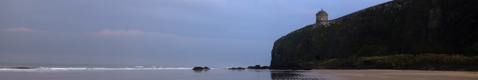
If you look at the top left corner of the first picture you can see the Game of Thrones set location at Larrybane. And in the second picture the same location yesterday with just my car parked there haha. This site was where Brienne of Tarth was first introduced to the show back in Season 2 (I think).

larrybane (4)

Theres a huge sweeping bay below the old quarry at Larrybane and you can actually see the point in the far distance where Carrick-A-Rede rope bridge spans the gap in the cliffs if you look very closely. Its that V shaped cut in the rocks just left of center towards the back of the picture. I have included a close up of it I took below.

larrybane (6)

Some of the old quarry ruins that remain. Looking pretty ominous against the cloudy November sky.

The view from the top of the headland is pretty spectacular I must say. It was a reasonably overcast day but some parts of the sandy bottom of the sea were a stunning turquoise blue. The island you see in the first picture is known as Sheep Island. I didnt see any sheep on it (theyd have to be able to swim to get out there) but it has some old folklore history yet its now designated as an area of special scientific interest and human access is prohibited during bird nesting season.

larrybane (2)

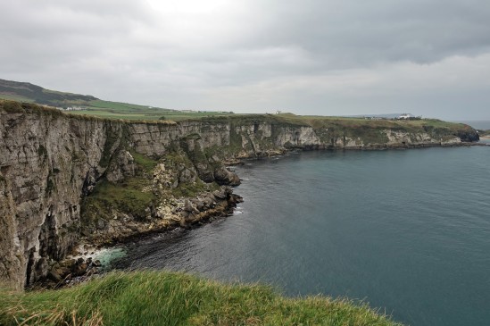
If you take one of the small trails through the grass at the top of the headland and look over the other side (be careful!), this is the view youll see. Its just as amazing as looking in the other direction and you might just be able to spot Ballintoy Church (which sits at the top of the road down to Ballintoy harbour) near the middle of the picture.

larrybane (8)

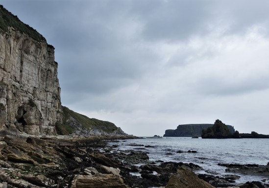
This was taken right down at the bottom of the cliffs (theres a crumbling old road to walk down) where the rubble and fallen limestone rocks from the quarry festoon the shoreline. You can see Sheep Island again in the background and I expect there may be some fossil hunting to be done down here at low tide.

larrybane (7)

This is a zoom in to the V shaped cut I mentioned in the rocks (on the second picture) where Carrick-A-Rede rope bridge crosses over the gap. You should actually be able to see the people crossing it. Its a bit of a walk to get to the bridge and once you do it youd likely not go again, but the walk there has everyone looking back towards Larrybane as the view behind you is so stunning. Personally I enjoyed visiting Larrybane (FREE!) just as much as the bridge. And it didnt have hordes of tourist bus passengers either walking in file to get there 😀


Craigmore Railway Viaduct, Newry

The Craigmore Viaduct (Irish: an Tarbhealach Craig Mór, meaning “the great rock trans-way”) is a railway bridge near Bessbrook, County Armagh, locally known as the 18 Arches. Near Newry railway station.

The bridge was designed by John Benjamin Macneill, an eminent Irish civil engineer, with construction beginning in 1849 for the Dublin and Belfast Junction Railway. The bridge was formally opened in 1852. It spans the valley of Camlough River. The viaduct consists of 18 arches of 60 ft span, the highest being 126 ft, making Craigmore the highest viaduct in Ireland. It is around a quarter of a mile long and was constructed from granite stone blocks from the nearby Goraghwood quarry near Goraghwood station, which for many years supplied ballast to the Dublin & Belfast Junction Railway’s lines.

craigmore (5)

A beautiful day underneath Craigmore

craigmore (1)

The Dublin-Belfast railway line crosses the bridge. From 1885 to 1948, the Bessbrook and Newry Tramway ran under the viaduct. On 2 March 1989, a Provisional Irish Republican Army bomb damaged Craigmore Viaduct, exploding just four minutes before a passenger train from Dublin was due to leave nearby Newry Station. A clearance operation had to be mounted and the railway line was closed and not reopened until 8 March 1989.

craigmore (3)

Hares Gap, Mourne Walks, County Down, Newcastle

Hares Gap is one of the easier walks through the Mournes and like most its quite accessible too. From the road you would hardly know its there but park up at the Trassey Road car park and climb over the stile (or just open the gate) and follow the path into this part of the Mournes. 

hgap (2) hgap (3)

You can park your car either in the car park a little up the road from this sign or at the side of the road (fold your mirrors in its narrow passing here). The second picture is taken off an information board at the car park.

hgap (5) hgap (24) hgap (25)

After you climb over the stile (or open the gate) follow the road past some obvious deforesting that’s taking place. I’m not sure what this old wood looked like during its finer days, but Clonachullion is no more. Maybe there was some disease in there and he had to go. Anyway, marvel at the piles of timber as you pass by.

hgap (6)hgap (4) hgap (7) hgap (8)

As you turn the corner past the wood you’ll catch your first glimpse of the beautiful Mourne mountains ahead. The sign warns of weather preparations required at certain times of the year but today it was just wonderfully warm.

hgap (10) hgap (11) hgap (12)

I’m not sure what fate befell the young boy whos memorial is placed here, but 20yrs ago (this year) something bad happened during the trek ahead, pay your respects and enter through the gate and admire the view to your right as the wall fades off into the distance.

hgap (15) hgap (16) hgap (17)

Theres a crystal clear mountain stream here tumbling down the hills which I suspect is fine to drink, but even if its just to splash your face or dip your toes in (to cool down) its still appreciated. On the second picture you can see the Mourne wall on the horizon (the straight bit) which is the back side of the wall we walked up to on the Glen River walk (see elsewhere on the site for that) and you might just be able to pick out an old quarry up to the right as well where they mined granite in this area. On the third picture is an ominous warning to dog owners which I suspect has been placed by some irate farmer that’s had his sheep attacked. I haven’t heard of anyones dog being shot, but please keep your animals under control if you come up here. This is private land and you’re only a guest being allowed to walk here.

hgap (18) hgap (19) hgap (20) hgap (22)

The magnificent Hares Gap. You can clearly see how the glaciers cut their way through here around 60 million years ago. Since then, man has made his way along this route either to mine granite or to smuggle goods (Hare’s Gap marked the exit point for smuggled contraband including soap, leather, spices and coffee and was carried through the mountains on the backs of small ponies which descended via the Hare’s Gap to the valley of the Trassey River and on to Hilltown – a favourite distribution centre. Today though its just a wonderful location for a fantastic Northern Ireland walk.