Larrybane, Game of Thrones Location, Co.Antrim.

I took a drive up to a place called Larrybane yesterday which is halfway between Ballintoy (another GoT location, see my posts on it) and Carrick-a-Rede rope bridge. In fact to get there you have to follow the signs for Carrick-a-Rede and park up in one of the two car parks when you arrive (the first one you come to is for the bridge but theres a another one lower down thats better for Larrybane). The good thing is, Larrybane is completely free to access (the bridge is a pricey £7.50 each but hey, we all know by now that the National Trust is very good at robbing tourists eh? We’ve all become aware of their dodgy Giants Causeway shenanigans) and its really worth investigating – especially if youre a Game of Thrones fan and youve just visited Ballintoy mere minutes away. Larrybane was once a busy old limestone quarry and you can still see the remnants of the works buildings there.  

If you look at the top left corner of the first picture you can see the Game of Thrones set location at Larrybane. And in the second picture the same location yesterday with just my car parked there haha. This site was where Brienne of Tarth was first introduced to the show back in Season 2 (I think).

larrybane (4)

Theres a huge sweeping bay below the old quarry at Larrybane and you can actually see the point in the far distance where Carrick-A-Rede rope bridge spans the gap in the cliffs if you look very closely. Its that V shaped cut in the rocks just left of center towards the back of the picture. I have included a close up of it I took below.

larrybane (6)

Some of the old quarry ruins that remain. Looking pretty ominous against the cloudy November sky.

The view from the top of the headland is pretty spectacular I must say. It was a reasonably overcast day but some parts of the sandy bottom of the sea were a stunning turquoise blue. The island you see in the first picture is known as Sheep Island. I didnt see any sheep on it (theyd have to be able to swim to get out there) but it has some old folklore history yet its now designated as an area of special scientific interest and human access is prohibited during bird nesting season.
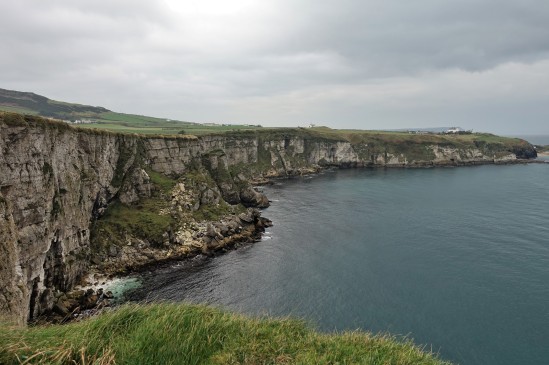
larrybane (2)

If you take one of the small trails through the grass at the top of the headland and look over the other side (be careful!), this is the view youll see. Its just as amazing as looking in the other direction and you might just be able to spot Ballintoy Church (which sits at the top of the road down to Ballintoy harbour) near the middle of the picture.
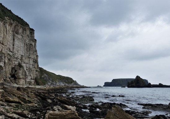
larrybane (8)

This was taken right down at the bottom of the cliffs (theres a crumbling old road to walk down) where the rubble and fallen limestone rocks from the quarry festoon the shoreline. You can see Sheep Island again in the background and I expect there may be some fossil hunting to be done down here at low tide.

larrybane (7)

This is a zoom in to the V shaped cut I mentioned in the rocks (on the second picture) where Carrick-A-Rede rope bridge crosses over the gap. You should actually be able to see the people crossing it. Its a bit of a walk to get to the bridge and once you do it youd likely not go again, but the walk there has everyone looking back towards Larrybane as the view behind you is so stunning. Personally I enjoyed visiting Larrybane (FREE!) just as much as the bridge. And it didnt have hordes of tourist bus passengers either walking in file to get there 😀


North Coast Dreams (video) Slideshow of the Causeway Coast County Antrim.

Ive created a little slideshow video here of several pictures Ive taken around the North Antrim coastline. Its my first attempt at this so forgive its amateurish limitations. Locations seen include Castlerock, Binevenagh, Portrush, Portstewart, Dunseverick, Port Moon, Gortmore, White Rocks, and a glimpse of Dunluce Castle.


Port Moon, County Antrim, Causeway Coast

A while ago I posted some pictures taken at Dunseverick Grasslands which involved climbing over the wall at the Dunseverick Castle layby and walking right around the headland there. Its a truly stunning walk and one thats hidden from the road so it can only be accessed on foot. There is another walk in the opposite direction however which is just as amazing towards a magical little bay called Port Moon.

moon-1

Port Moon has a long history of fishing going back well over 200 years and from 1830 nets were attached to the rocks offshore to catch Atlantic salmon on their journey to the river Bush for spawning. Crabs, lobsters and kelp were also harvested here.

moon-2

One of the crags jutting out into the sea on the walk to Port Moon, clearly showing the hexagonal columns which cover this area very close to the Giants Causeway (less than 5mls away).

moon-3 moon-4

Your first views of the little “Fish House” bothy seen from several hundred feet above Port Moon bay (and yes, you can climb down there if youre brave enough).

moon-6 moon-5

The surrounding area is simply stunning.

moon-7

After climbing down the looping path to the bottom of the cliff (it looks much more scary than it actually is, but be careful if its been raining as it can be slippery) you arrive at the old Fish house which now operates as a bothy (a small hut or cottage used as a refuge) which you can arrange to stay at if youre feeling adventurous (see here: http://www.canoeni.com/canoe-trails/north-coast-sea-kayak-trail/access-point/port-moon/ ). The building used to house all fishing operations at Port Moon but had fallen into disrepair until it was resurrected as a bothy in 2011. There are some pictures of the inside here https://www.hikersblog.co.uk/an-overnight-stay-in-port-moon-bothy/ but normally its locked.

moon-9 moon-8

Looking out across the bay from the Port Moon shore. Not bad for a wintery February morning!

moon-10

The bothy seen from the opposite side of the crescent shaped (moon shaped) bay.

moon-11 moon-12

Port Moon, a magical little place now deserted and haunted by the ghosts of its fishing past. Its really worth seeing and its very much an undiscovered gem of NI that most residents wont even have seen. Dunseverick Castle may not be much to look at but once over that wall and walking either left or right youll surely be impressed.


Mourne Mountains Walk – Slieve Binnian (from Carrick Little car park) County Down, Annalong

There are so many amazing walks through the Mourne mountain range in County Down, and sometimes its just hard to fathom how such a vast area even exists in Northern Ireland given the country is so small. When you’re in middle of any of these walks you can see for miles (sometimes without a person, or particularly any sign of civilization, in sight). Which is a fantastic feeling when you just want to get away from it all.

For this route, make your way to the Carrick Little car park which is at the junction of the Head Road and Oldtown Road near Annalong. The Mourne Rambler bus departs from Newcastle Bus station on a regular basis during the summer months for here.


Slieve Binnian (5)

From the Carrick Little car park, follow a clear, stony track that rises gently between the fields. Note the boulder walls alongside. You’ll soon see this old cottage in the middle of a field to your left. I wonder who lived here?


Slieve Binnian (45)

At this point leave the wide trail here and go over to your left following the stone wall that takes you upward to Slieve Binnian (thats it ahead in the picture).


Slieve Binnian (13)

We were lucky with the weather as the Mournes can be unpredictable (bring some suitable gear anytime you visit outside the Summer months). Its not long before you’re treated to a stunning view like this. Thats Slieve Donard in the distance here (just right of center of the picture) the highest peak not only of the Mournes but in the whole of Northern Ireland.


Slieve Binnian (17)

About half way up the climb we veered right (following the wall cutting diagonally right across the second photo above here) as we hadn’t been up this way before, there was a still a reasonable climb (as you can see from the height of the pics) but it wasn’t as exhausting as the climb to the very top of Binnian. We followed the direction of the old stone wall (to the top of THIS climb) and looked across the valley below…


Slieve Binnian (25)

Climbing down from here you’ll come to a massive boulder ahead (dropped by the glacial ice retreat thousands of years ago). And on one edge of a rock you might see this……I shall name him….. Dragonstone haha 🙂


Slieve Binnian (30)

Just below you (beyond the big rock above) you should be able to see this small lake. We descended down to it and admired its peaceful tranquility…


Slieve Binnian (40)

A final look across the landscape of this part of the Mourne Mountains. You could easily spend a week hiking through here. For more information on walking this area see here:   http://www.walkni.com/walks/67/slieve-binnian/