Yes, the title above is likely a bit of a mouthful for those visiting from foreign shores, but these place names are said pretty much phonetically so don’t worry haha. On a chilly, but bright February morning (2015), I set off for a drive to see where I would end up. The intention was to locate at least one of the ancient burial “Dolmen” dotted around the South County Down area and I guess I managed to find one even if it was almost by accident. It looks as if there are at least seven in the surrounding countryside, and I find it truly fascinating that these monuments are still standing after nearly 5000 years. Northern Ireland’s ancient history seems very well hidden though!


These are just a couple of pictures I took of Loughbrickland Lake in County Down while going South. Its just off the main Belfast to Dublin (A1) road and as I hadn’t seen it frozen over before I swerved off the motorway and grabbed a few shots before heading on. The lake holds brown and rainbow trout and can be fly fished during the season.

After finding the road sign for the “Slieve Croob Scenic Loop” (look for the brown coloured signs near Castlewellan) I turned off the main road and headed off onto (what became) a track not much wider than my car at times. I think this wasn’t helped by a fall of snow up there, with much of it still piled at the side of the route. That said, the views were stunning over the snow dusted valley.


Slieve Croob meaning “mountain of the hoof” is the tallest of a group of peaks in the middle of County Down. These peaks lie north of the Mourne Mountains, between the village of Dromara and the town of Castlewellan. Slieve Croob has been designated an Area of Outstanding Natural Beauty. It is the source of the River Lagan, which starts as a spring and runs from here, through Dromara, Dromore, County Down, Lisburn and Belfast, where it enters Belfast Lough.
Folklore tells that 12 kings are buried at the top of the Mountain and each year it is traditional to climb the hill on the first Sunday in August (known as Cairn Sunday or Blaeburry Sunday) and carry with you a stone to help bury the kings. In recent times there is traditional Irish music played at the top of the Mountain on this date.

A sheep thankful for his wooly coat at Slieve Croob.

A dolmen, also known as a portal tomb, portal grave or quoit, is a type of single-chamber megalithic tomb, usually consisting of two or more upright stones supporting a large flat horizontal capstone (table), although there are also more complex variants. Most date from the early Neolithic period (4000 to 3000 BC). Dolmens were typically covered with earth or smaller stones to form a barrow. In many instances, that covering has weathered away, leaving only the stone “skeleton” of the burial mound intact.
It remains unclear when, why, and by whom the earliest dolmens were made. The oldest known dolmens are in Western Europe, where they were set in place around 7000 years ago. Archaeologists still do not know who erected these dolmens, which makes it difficult to know why they did it. They are generally all regarded as tombs or burial chambers, despite the absence of clear evidence for this. Human remains, sometimes accompanied by artifacts, have been found in or close to the dolmens which could be scientifically dated. However, it has been impossible to prove that these archaeological remains date from the time when the stones were originally set in place. Dolmens have also been found in Korea, Spain, and India.

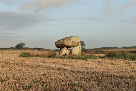
Legananny Dolmen sits up a lane behind a farmers house (its ok to walk up and see it without asking permission) and its astounding how this thing has sat here for so long. Im sure it would have some stories to tell based on what its seen for 5 millennia. Its so great to see these remnants of Irelands older non-christian history, and hopefully they shall remain for many more 1000s of years to come. Though given that some (apparent) Christians recently pulled down a monument at Gortmore, putting a cross in its place saying “You shall have no other Gods before me” then who knows. Story: http://www.londonderrysentinel.co.uk/news/local-news/manannan-mac-lir-pagan-priest-says-statue-theft-a-hate-crime-1-6543319 a Facebook campaign has now begun to try and replace it.


Legananny Dolmen is a megalithic dolmen three miles north of Castlewellan, in County Down. It is on the slopes of Slieve Croob near the village of Leitrim, nestled between a farmer’s stone wall and a back road. It is a State Care Historic Monument. This tripod dolmen has a capstone over 3m long and 1.8m from the ground. It dates to the Neolithic period, making the monument approximately 5,000 years old. Such portal tombs were funerary sites for the disposal of the dead in Neolithic society. The heavy stones would have been dragged some distance before being set in place. The three supporting stones are unusually long and some ancient urns were found underneath. The name Legananny is believed to be derived from Irish Liagán Áine, meaning “Áine’s standing stone” – Áine being an Irish goddess.

After leaving Legananny I drove on a few kilometers and parked at the car park at Windy Gap (hmm, I reckon not too much thought went into that one lol).


The view was beautiful (and actually it wasn’t windy at all) and in the second picture here you can see (almost) the entire Mourne Mountain range in the distance.

No picnics today at Windy Gap. Brrr!

A far off glimpse of the highest peak in Northern Ireland, Slieve Donard, with a little wisp of cloud caught on the top. Once again, I explored (marvelously) alone that morning and if you visit NI you really should hire a car and get away from the obvious tourist traps like the Titanic Quarter and Black taxi mural tours etc. We have so much more to show you than those things!


