Helens Bay, Co.Down 10th January 2016

I haven’t posted anything in a while with a few personal things going on, but new year brings new intentions to get things going again, and as ever, the idea is to show just what Northern Ireland has to offer beyond its troubles of the past and its big ship that sunk in the night. There’s much more to our tiny country than those black taxis around tainted murals, or even the wonderful Giants Causeway. Have a look and see what has lay hidden for decades from most travellers eyes, and where most sights are never more than 120mins apart.

All photos were taken with only my Sony compact camera, so my pictures actually are of what you will see (no hyper-realistic SLR pix here as I prefer to show reality). Heres to a great new year of 2016 and I hope it brings each and every one of you much happiness 😀


HELENS BAY – SEAHILL Coastal path, on the evening of January 10th 2016


Helens Bay - Seahill 10.01 (1)

The weather in the north of Ireland (in fact all of the UK and Ireland) has been the wettest ever on record this winter, so we’ve barely seen the sun in weeks. Last night however there was a little glimmer of gold as the day began to fade so we went out for a walk along the shores of Belfast Lough and grabbed a few pics.


Helens Bay - Seahill 10.01 (2)


You cant really see it here, but this is looking across the lough towards Carrickfergus from Helens Bay


Helens Bay - Seahill 10.01 (4)

A rocky beach between Helens Bay and Seahill


Helens Bay - Seahill 10.01 (5)

You might just be able to see a little bench to sit on to the left here, but we decided not to given it was very, very cold!


Helens Bay - Seahill 10.01 (3)

After all that rain, much of the path was muddy and puddled, but it made a nice feature in this picture.


Helens Bay - Seahill 10.01 (6)

Daylight almost gone now, the last embers of light fading into a January night.

Mourne Mountains Walk – Slieve Binnian (from Carrick Little car park) County Down, Annalong

There are so many amazing walks through the Mourne mountain range in County Down, and sometimes its just hard to fathom how such a vast area even exists in Northern Ireland given the country is so small. When you’re in middle of any of these walks you can see for miles (sometimes without a person, or particularly any sign of civilization, in sight). Which is a fantastic feeling when you just want to get away from it all.

For this route, make your way to the Carrick Little car park which is at the junction of the Head Road and Oldtown Road near Annalong. The Mourne Rambler bus departs from Newcastle Bus station on a regular basis during the summer months for here.


Slieve Binnian (5)

From the Carrick Little car park, follow a clear, stony track that rises gently between the fields. Note the boulder walls alongside. You’ll soon see this old cottage in the middle of a field to your left. I wonder who lived here?


Slieve Binnian (45)

At this point leave the wide trail here and go over to your left following the stone wall that takes you upward to Slieve Binnian (thats it ahead in the picture).


Slieve Binnian (13)

We were lucky with the weather as the Mournes can be unpredictable (bring some suitable gear anytime you visit outside the Summer months). Its not long before you’re treated to a stunning view like this. Thats Slieve Donard in the distance here (just right of center of the picture) the highest peak not only of the Mournes but in the whole of Northern Ireland.


Slieve Binnian (17)

About half way up the climb we veered right (following the wall cutting diagonally right across the second photo above here) as we hadn’t been up this way before, there was a still a reasonable climb (as you can see from the height of the pics) but it wasn’t as exhausting as the climb to the very top of Binnian. We followed the direction of the old stone wall (to the top of THIS climb) and looked across the valley below…


Slieve Binnian (25)

Climbing down from here you’ll come to a massive boulder ahead (dropped by the glacial ice retreat thousands of years ago). And on one edge of a rock you might see this……I shall name him….. Dragonstone haha 🙂


Slieve Binnian (30)

Just below you (beyond the big rock above) you should be able to see this small lake. We descended down to it and admired its peaceful tranquility…


Slieve Binnian (40)

A final look across the landscape of this part of the Mourne Mountains. You could easily spend a week hiking through here. For more information on walking this area see here:   http://www.walkni.com/walks/67/slieve-binnian/


Hares Gap, Mourne Walks, County Down, Newcastle

Hares Gap is one of the easier walks through the Mournes and like most its quite accessible too. From the road you would hardly know its there but park up at the Trassey Road car park and climb over the stile (or just open the gate) and follow the path into this part of the Mournes. 

hgap (2) hgap (3)

You can park your car either in the car park a little up the road from this sign or at the side of the road (fold your mirrors in its narrow passing here). The second picture is taken off an information board at the car park.

hgap (5) hgap (24) hgap (25)

After you climb over the stile (or open the gate) follow the road past some obvious deforesting that’s taking place. I’m not sure what this old wood looked like during its finer days, but Clonachullion is no more. Maybe there was some disease in there and he had to go. Anyway, marvel at the piles of timber as you pass by.

hgap (6)hgap (4) hgap (7) hgap (8)

As you turn the corner past the wood you’ll catch your first glimpse of the beautiful Mourne mountains ahead. The sign warns of weather preparations required at certain times of the year but today it was just wonderfully warm.

hgap (10) hgap (11) hgap (12)

I’m not sure what fate befell the young boy whos memorial is placed here, but 20yrs ago (this year) something bad happened during the trek ahead, pay your respects and enter through the gate and admire the view to your right as the wall fades off into the distance.

hgap (15) hgap (16) hgap (17)

Theres a crystal clear mountain stream here tumbling down the hills which I suspect is fine to drink, but even if its just to splash your face or dip your toes in (to cool down) its still appreciated. On the second picture you can see the Mourne wall on the horizon (the straight bit) which is the back side of the wall we walked up to on the Glen River walk (see elsewhere on the site for that) and you might just be able to pick out an old quarry up to the right as well where they mined granite in this area. On the third picture is an ominous warning to dog owners which I suspect has been placed by some irate farmer that’s had his sheep attacked. I haven’t heard of anyones dog being shot, but please keep your animals under control if you come up here. This is private land and you’re only a guest being allowed to walk here.

hgap (18) hgap (19) hgap (20) hgap (22)

The magnificent Hares Gap. You can clearly see how the glaciers cut their way through here around 60 million years ago. Since then, man has made his way along this route either to mine granite or to smuggle goods (Hare’s Gap marked the exit point for smuggled contraband including soap, leather, spices and coffee and was carried through the mountains on the backs of small ponies which descended via the Hare’s Gap to the valley of the Trassey River and on to Hilltown – a favourite distribution centre. Today though its just a wonderful location for a fantastic Northern Ireland walk.

Cave Hill, Cavehill, Belfast, County Antrim

Cave Hill, sometimes spelt as Cavehill, is a basaltic hill overlooking the city of Belfast. It forms part of the southeastern border of the Antrim Plateau. Historically it was known as Ben Madigan, which is derived from the Irish Beann Mhadagáin, meaning “Madagán’s peak”—so named after a king of Ulster called Madagán who died in 856AD.

All of Belfast can be seen from its peak and Cave Hill is thought to be the inspiration for Jonathan Swift’s Gulliver’s Travels as Swift imagined that Cave Hill resembled the shape of a sleeping giant safeguarding the city.

cave hill belfast (1) cave hill belfast (2)

Cave Hill rises to almost 370 metres (1200 ft) above sea level. Most of its lower east side lies on the Belfast Castle estate. The slopes of Cave Hill were originally used as farmland but, from the 1880s, a major planting exercise was undertaken, producing the now familiar deciduous and coniferous woodland landscape. Belfast Castle estate was given to the City of Belfast by The 9th Earl of Shaftesbury in 1934.

There are three large caves. The lowest is 21 feet long, 18 feet wide and varies from 7 to 10 feet in height. Above this is another cave; 10 feet long, 7 feet wide and 6 feet in height. Above this is the third major cave, said to be divided into 2 unequal parts, each of which is more extensive than the larger of the other caves, but the ascent is notoriously dangerous and thus few venture up to it. The caves are entirely man-made, and it is thought that they were originally excavated for iron-mining.

cave hill belfast (3) cave hill belfast (5)

This is the easiest cave to access and the most easily visible from below. The climb up to this point (from the grounds of Belfast Castle) is probably the most tiresome part of the Cave Hill climb but its not beyond most peoples ability. Bring some water if you’re going up in the warmer months (and a coat in the colder ones!).

cave hill belfast (6)

The views from the top are pretty amazing with one side of the water being County Antrim, and the other County Down. You can see all of Belfast Lough and the ship here is the Stenaline service heading for Scotland (the vague shadow on the horizon). The chimney to the distant left of the picture is Kilroot power station which provides electricity for one third of Northern Ireland, and in the bottom foreground of the picture you can see Belfast Zoo (the brown bear cage I think).

cave hill belfast (15) cave hill belfast (9) cave hill belfast (12)

McArt’s Fort on the summit of the hill, is an example of an old ráth or ring fort. It is protected on one side by a precipice and on the others by a single ditch, 10 feet in depth and 25 feet in width. The enclosed area is nearly level. The flat top of the fort is 150 feet from north to south, and 180 feet from east to west. It is believed that the fort’s inhabitants used the caves to store food for the winter and may have served as a refuge during times of attack. If you look towards the bottom of the last picture you can see a cave there.

cave hill belfast (4) cave hill belfast (8) cave hill belfast (7)

Its certainly a nice trip out here as you get to explore the castle grounds before your climb (even entertain the kids with its adventure playground too) and to have a bit of wilderness so close to a city is pretty unique. Who would have thought, that even in March (and NI) you can get out and enjoy the countryside 🙂

cave hill belfast (11)

The residential neighbourhood at the foot of Cave Hill’s entrance is derivatively known as Ben Madigan, with street names to match, and is a wealthy semi-outer city, semi-suburban area. The name ‘Ben Madigan’ can also be found attached to buildings, schools etc. close to the area, e.g. the Belfast Royal Academy has the Ben Madigan Preparatory School on the Antrim Road.

During World War II, a bomb dropped during a German bombing raid on Belfast exploded, causing a large crater near the grounds of Belfast Castle. It is understood that RAF Bomber Command was situated on Cave Hill in the early years of WWII before relocating to Castle Archdale in County Fermanagh. On 1 June 1944, an American Air Force B-17 bomber crashed into Cave Hill during heavy fog, killing all ten crew instantly. The incident inspired Richard Attenborough’s film, “Closing the Ring” and some scenes of the film were shot on Cave Hill.

cave hill belfast (13) cave hill belfast (14)

One for you cloud spotters, and the rolling Belfast hill walkers.

Loughbrickland, Slieve Croob, Legananny Dolmen and Windy Gap County Down.

Yes, the title above is likely a bit of a mouthful for those visiting from foreign shores, but these place names are said pretty much phonetically so don’t worry haha. On a chilly, but bright February morning (2015), I set off for a drive to see where I would end up. The intention was to locate at least one of the ancient burial “Dolmen” dotted around the South County Down area and I guess I managed to find one even if it was almost by accident. It looks as if there are at least seven in the surrounding countryside, and I find it truly fascinating that these monuments are still standing after nearly 5000 years. Northern Ireland’s ancient history seems very well hidden though!

loughbrickland (1) loughbrickland (3)

These are just a couple of pictures I took of Loughbrickland Lake in County Down while going South. Its just off the main Belfast to Dublin (A1) road and as I hadn’t seen it frozen over before I swerved off the motorway and grabbed a few shots before heading on. The lake holds brown and rainbow trout and can be fly fished during the season.

slieve croob (1)

After finding the road sign for the “Slieve Croob Scenic Loop” (look for the brown coloured signs near Castlewellan) I turned off the main road and headed off onto (what became) a track not much wider than my car at times. I think this wasn’t helped by a fall of snow up there, with much of it still piled at the side of the route. That said, the views were stunning over the snow dusted valley.

slieve croob (4) slieve croob (5)

Slieve Croob meaning “mountain of the hoof” is the tallest of a group of peaks in the middle of County Down. These peaks lie north of the Mourne Mountains, between the village of Dromara and the town of Castlewellan. Slieve Croob has been designated an Area of Outstanding Natural Beauty. It is the source of the River Lagan, which starts as a spring and runs from here, through Dromara, Dromore, County Down, Lisburn and Belfast, where it enters Belfast Lough.

Folklore tells that 12 kings are buried at the top of the Mountain and each year it is traditional to climb the hill on the first Sunday in August (known as Cairn Sunday or Blaeburry Sunday) and carry with you a stone to help bury the kings. In recent times there is traditional Irish music played at the top of the Mountain on this date.

slieve croob (2)

A sheep thankful for his wooly coat at Slieve Croob.

legananny (1)

A dolmen, also known as a portal tomb, portal grave or quoit, is a type of single-chamber megalithic tomb, usually consisting of two or more upright stones supporting a large flat horizontal capstone (table), although there are also more complex variants. Most date from the early Neolithic period (4000 to 3000 BC). Dolmens were typically covered with earth or smaller stones to form a barrow. In many instances, that covering has weathered away, leaving only the stone “skeleton” of the burial mound intact.

It remains unclear when, why, and by whom the earliest dolmens were made. The oldest known dolmens are in Western Europe, where they were set in place around 7000 years ago. Archaeologists still do not know who erected these dolmens, which makes it difficult to know why they did it. They are generally all regarded as tombs or burial chambers, despite the absence of clear evidence for this. Human remains, sometimes accompanied by artifacts, have been found in or close to the dolmens which could be scientifically dated. However, it has been impossible to prove that these archaeological remains date from the time when the stones were originally set in place. Dolmens have also been found in Korea, Spain, and India.

legananny (2)

Legananny Dolmen sits up a lane behind a farmers house (its ok to walk up and see it without asking permission) and its astounding how this thing has sat here for so long. Im sure it would have some stories to tell based on what its seen for 5 millennia. Its so great to see these remnants of Irelands older non-christian history, and hopefully they shall remain for many more 1000s of years to come. Though given that some (apparent) Christians recently pulled down a monument at Gortmore, putting a cross in its place saying “You shall have no other Gods before me” then who knows. Story: http://www.londonderrysentinel.co.uk/news/local-news/manannan-mac-lir-pagan-priest-says-statue-theft-a-hate-crime-1-6543319 a Facebook campaign has now begun to try and replace it.

legananny (3) legananny (4)

Legananny Dolmen is a megalithic dolmen three miles north of Castlewellan, in County Down. It is on the slopes of Slieve Croob near the village of Leitrim, nestled between a farmer’s stone wall and a back road. It is a State Care Historic Monument. This tripod dolmen has a capstone over 3m long and 1.8m from the ground. It dates to the Neolithic period, making the monument approximately 5,000 years old. Such portal tombs were funerary sites for the disposal of the dead in Neolithic society. The heavy stones would have been dragged some distance before being set in place. The three supporting stones are unusually long and some ancient urns were found underneath. The name Legananny is believed to be derived from Irish Liagán Áine, meaning “Áine’s standing stone” – Áine being an Irish goddess.

windy gap (1)

After leaving Legananny I drove on a few kilometers and parked at the car park at Windy Gap (hmm, I reckon not too much thought went into that one lol).

windy gap (2) windy gap (5)

The view was beautiful (and actually it wasn’t windy at all) and in the second picture here you can see (almost) the entire Mourne Mountain range in the distance.

windy gap (3)

No picnics today at Windy Gap. Brrr!

windy gap (4)

A far off glimpse of the highest peak in Northern Ireland, Slieve Donard, with a little wisp of cloud caught on the top. Once again, I explored (marvelously) alone that morning and if you visit NI you really should hire a car and get away from the obvious tourist traps like the Titanic Quarter and Black taxi mural tours etc. We have so much more to show you than those things!

Kircubbin, County Down

Sitting on the shores of Strangford Lough, Kircubbin is a small town with a harbour sitting between Newtownards and Portaferry.

kircubbin (6)

Kircubbin, County Down.

kircubbin (1)

The old harbour at Kircubbin with a lost lobster creel. The harbour looks like its seen better days.

kircubbin (3)

On the edge of the harbour there’s this stone, I cant find anything on Google as to whether its true or not, but I doubt someone would go to the trouble of making it if not.

kircubbin (7)

The view out to sea from the harbour.

kircubbin (11) kircubbin (12)

kircubbin (8)

An old antique shop on the main street. now an antique itself.

Castlewellan Forest Park, Peace Maze, and Lake, Co.Down, Northern Ireland

Northern Irelands largest forest park, Tollymore (in Newcastle), usually gets most of the interest from our forest hungry visitors, but just a short drive away lies Castlewellan Forest Park, which has a beauty all of its own. In fact the facilities here in Castlewellan easily match its larger brother, and coupled with a huge maze, several lakes, two cafes, and a brilliant bike hire office, make it well worth checking out. Our visit on the 28th December 2014 showed the park to be surprisingly busy, which was great to see in (what was) the depths of Winter. I hope the photos we took entice others to come here too. You’ll love it. 

CASTLEWELLAN CASTLE

CASTLEWELLAN 28.12 (2) CASTLEWELLAN 28.12 (1) CASTLEWELLAN 28.12 (23) CASTLEWELLAN 28.12 (19)

The dominant feature of the forest park, Castlewellan Castle was built in 1856 by William Richard Annesley, it overlooks the huge lake below and can be seen as soon as you enter the park. Today it is a center for many church, and school organizations. There are signs to say the immediate area around the castle is private, but we had no issues walking around its grounds to take some photos. Theres a little black cat who comes out to say hello too. Miaow.

CASTLEWELLAN LAKE

CASTLEWELLAN 28.12 (3) CASTLEWELLAN 28.12 (9) CASTLEWELLAN 28.12 (12) CASTLEWELLAN 28.12 (11) CASTLEWELLAN 28.12 (10) CASTLEWELLAN 28.12 (5) CASTLEWELLAN 28.12 (4) CASTLEWELLAN 28.12 (6)

On this lovely, frost glistening, December morning we had so many great photo opportunities and began snapping away frantically. The largest lake in the park is nearly one mile long, and there’s a fantastic circular path around its shore taking in much of the forest along the way. The route is a big hit with cyclists and there’s even a place to hire bikes if you don’t have one. The distance around the lake is about 2.4miles but its a very easy (and enjoyable) trek. The lake can also be fished. For more info see here: http://www.walkni.com/walks/222/castlewellan-forest-park-lakeside-walk/

ANNESLEY GARDENS (WITHIN THE PARK)

CASTLEWELLAN 28.12 (14) CASTLEWELLAN 28.12 (13) CASTLEWELLAN 28.12 (15) CASTLEWELLAN 28.12 (16) CASTLEWELLAN 28.12 (17) CASTLEWELLAN 28.12 (18) CASTLEWELLAN 28.12 (8) CASTLEWELLAN 28.12 (7)

To access Castlewellan Forest Park you pay just £4.50 per car which is pretty good as it doesn’t matter how many are in your car. Once parked your entrance fee includes all the walks and the gardens which are wonderful in Winter but must be even nicer in the other three milder seasons of the year.

The planting of the walled Annesley garden, the focus of the arboretum, began in the 1850s and rare conifers and maples were later imported directly from Japan. Then came the addition of more rich varieties, including Chilean eucryphias, Australian athrotaxis and pittosporum and Chinese rhododendrons. The arboretum holds many trees with record heights in the British Isles (see one of the monsters above!).

THE PEACE MAZE

CASTLEWELLAN 28.12 (20) CASTLEWELLAN 28.12 (22)

CASTLEWELLAN 28.12 (21)

The “Peace Maze” was opened in 2000 and while you may think its nothing more than a quaint curiosity on entering you’re going to be in for a shock. This is one of the worlds largest permanent hedge mazes (it was the largest in the world until 2007 when it was beaten, only slightly, by a maze in Hawaii) and it really will offer a challenge to those without a pigeons sense of direction. The maze covers 3 acres and has 2.18 miles of pathway (the one in Hawaii has 2.46) and upon reaching the center there is a bell you can ring which is said to be the most rung bell in Ireland with half a million rings a year. When you visit the park make sure you go inside and see if you can find your way to the center (on top of the footbridge). Good luck! You’ll need it. The panaoramic picture above shows Castlewellan town, the Mourne Mountains, and a small part of the maze.

For more info on this great forest park see here: http://www.discovernorthernireland.com/Castlewellan-Forest-Park-and-Peace-Maze-Castlewellan-P2881

Tyrella Beach, County Down, December 28th 2014

Like most, we sat in the house over Christmas, eating, drinking, watching (terrible) TV, with some eating, and drinking (sorry, did I say that already?) and by the time the 28th of December came we decided we just had to get the hell out of the house as we felt like stuffed pigs. Luckily, the weather was amazing (though cold) so we headed off in the direction of Castlewellan (near Newcastle, Co.Down) to explore a little. After a few well needed coffees, and about a 40 minute drive, we followed the sign for Tyrella beach…

TYRELLA 28.12.14 (9) 

Tyrella is situated in an “Area Of Outstanding Natural Beauty” within Dundrum Bay. It is backed by a great sand dune complex with winding pathways where you can enjoy a sheltered walk.

TYRELLA 28.12.14 (1)

Our view from the car park as we arrived.

TYRELLA 28.12.14 (2)

Looking like Kilimanjaro, this is a relatively uncommon shot of Slieve Donard (part of the Mourne Mountains) sprinkled with snow on a blazing sunny day. It is the tallest mountain peak in Northern Ireland.

TYRELLA 28.12.14 (3)

A whole galaxy of rag worm sand casts at low tide Tyrella beach.

TYRELLA 28.12.14 (7)

The deserted sands at Tyrella, just 3 days after Christmas 2014.

TYRELLA 28.12.14 (5)

A rider and horse the only other living thing we saw that morning.

TYRELLA 28.12.14 (4)

A beautiful scene.

TYRELLA 28.12.14 (6)

Our final view before we headed back to our car for the trip to Castlewellan Forest Park, just a few miles up the road.

A Winter Afternoon in Belfast.

I’m going to be honest here, Belfast is far from being one of the most beautiful cities in the world. You have to look hard to find the (photographic) things of worth in its centre (and many you might not even notice as you walk by). They are there however, likely buried among some awful modern architecture and sadly run down streets. But I guess that happens in many cities, and Belfast has improved more than most since the dreadful days of the 70s and 80s here. We were in Belfast yesterday to do a bit of shopping, hoping for a visit to the Christmas Market (aka the Continental Market)…… more on that later though.
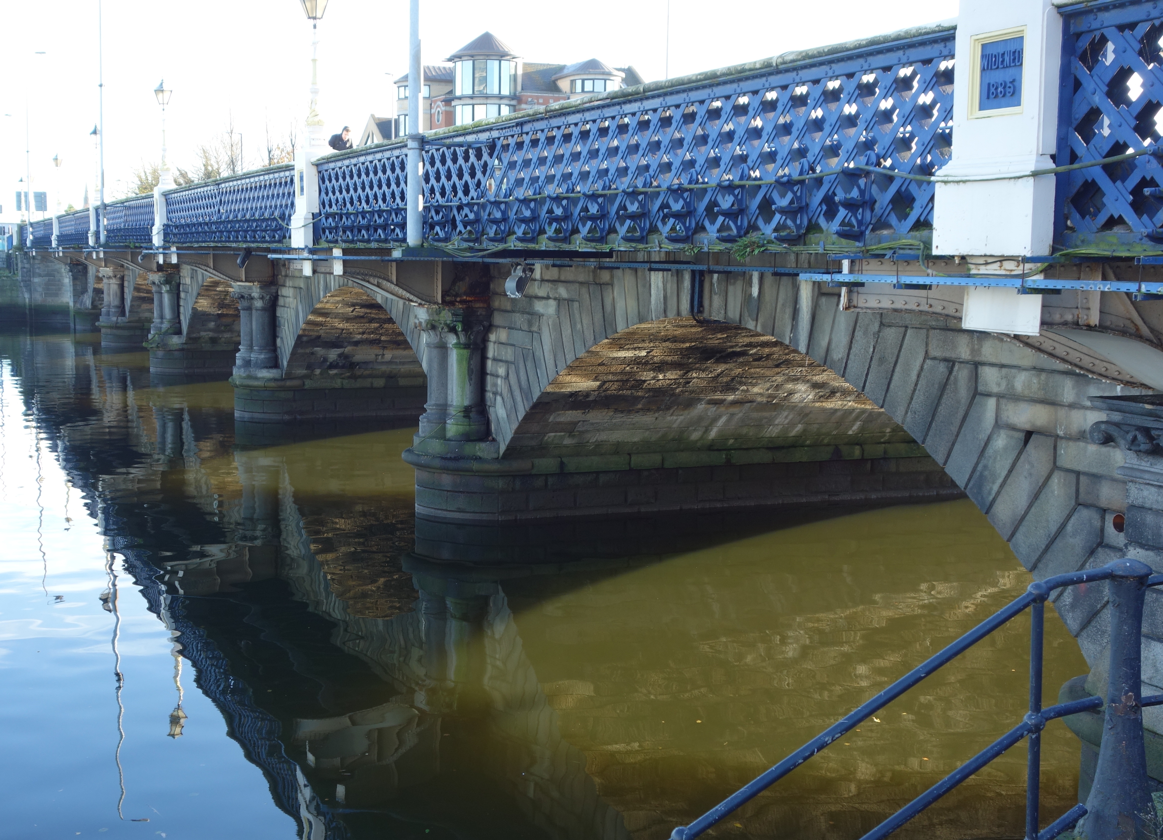
1 4

QUEENS BRIDGE

Queens Bridge in Belfast which opened in 1849. The first picture shows one of the ornate lamps fitted to the bridge (with the Obel Tower in the background – the tallest building in Ireland). It is one of eight bridges in the city, not to be confused with the adjacent Queen Elizabeth II Bridge. The sign on the bridge in the second photo says it was widened in 1885.
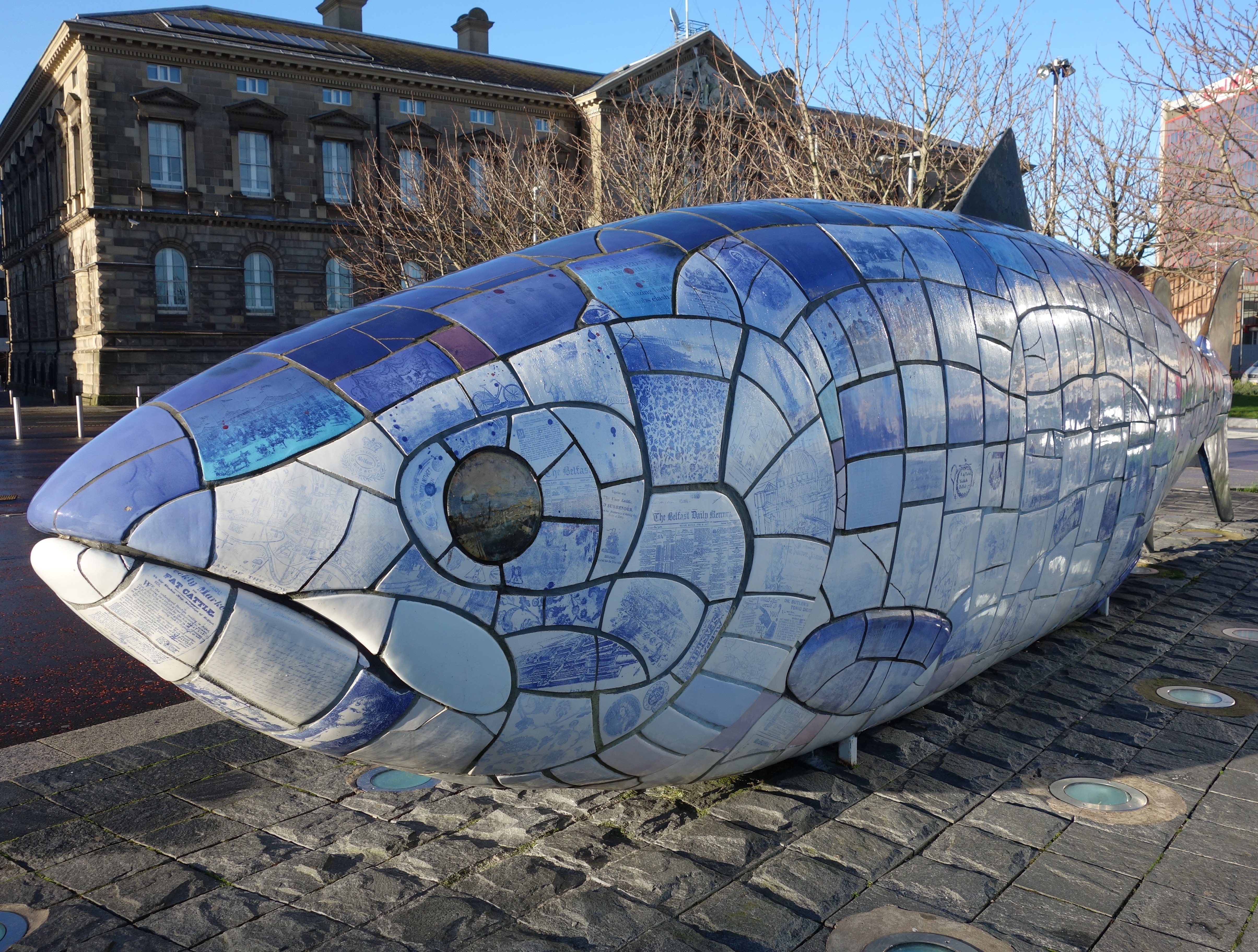
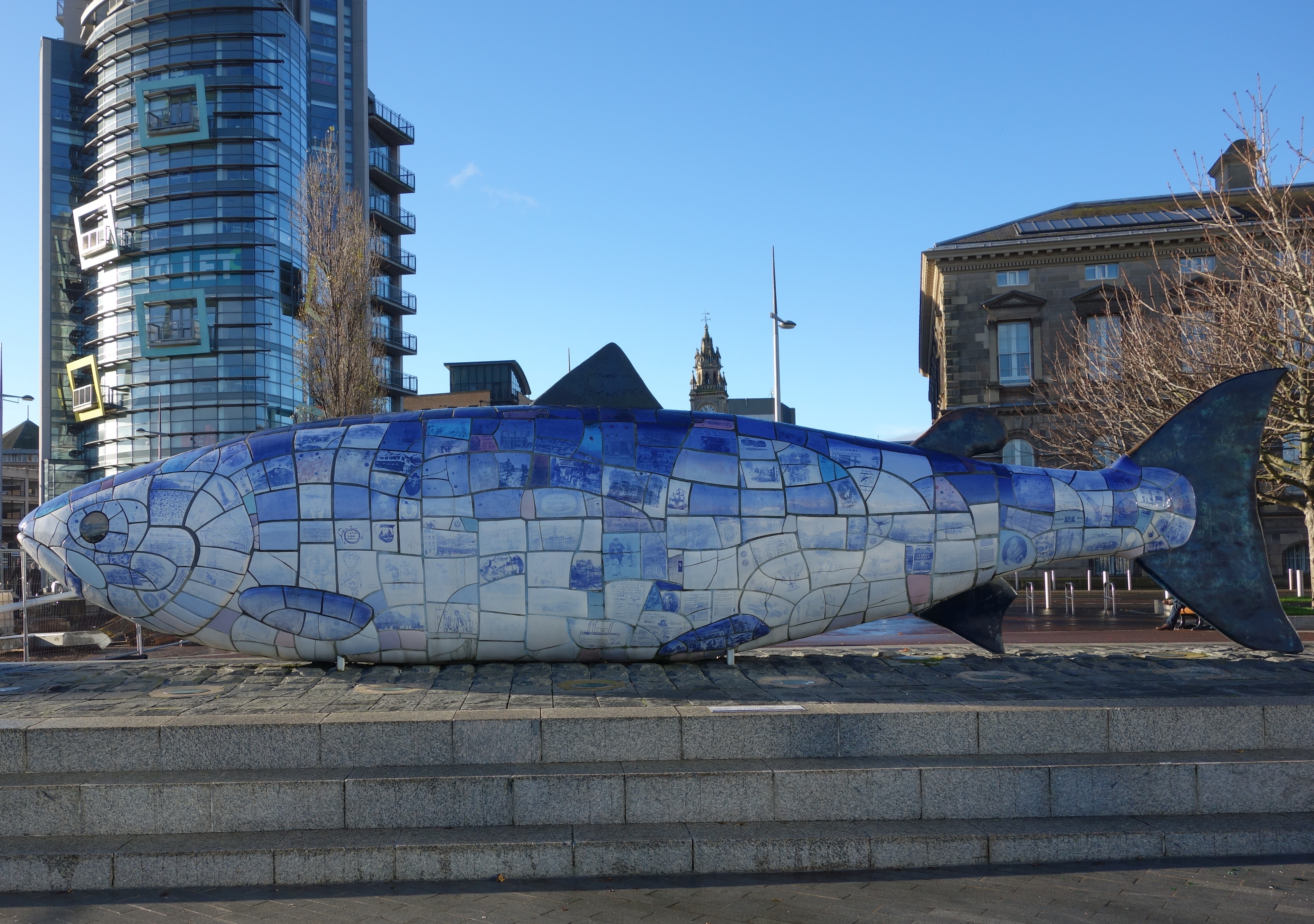
6 5 7

THE BIG FISH

The Big Fish – a printed ceramic sculpture by John Kindness, 10 metres long and constructed in 1999. Its at Donegall Quay, Belfast, near the Lagan Lookout and Custom House Square. The outer skin of the fish is a cladding of ceramic tiles decorated with texts and images relating to the history of Belfast. Material from Tudor times to present day newspaper headlines are included along with contributions from Belfast school children. The Ulster Museum provided the primary source of historic images, while local schools/day centres located along the line of the River Farset were approached to provide drawings for the fish. Images were provided by Glenwood Primary School, St Comgalls and Everton Day Centres. The Big Fish also contains a time capsule storing information/images/poetry on the City.
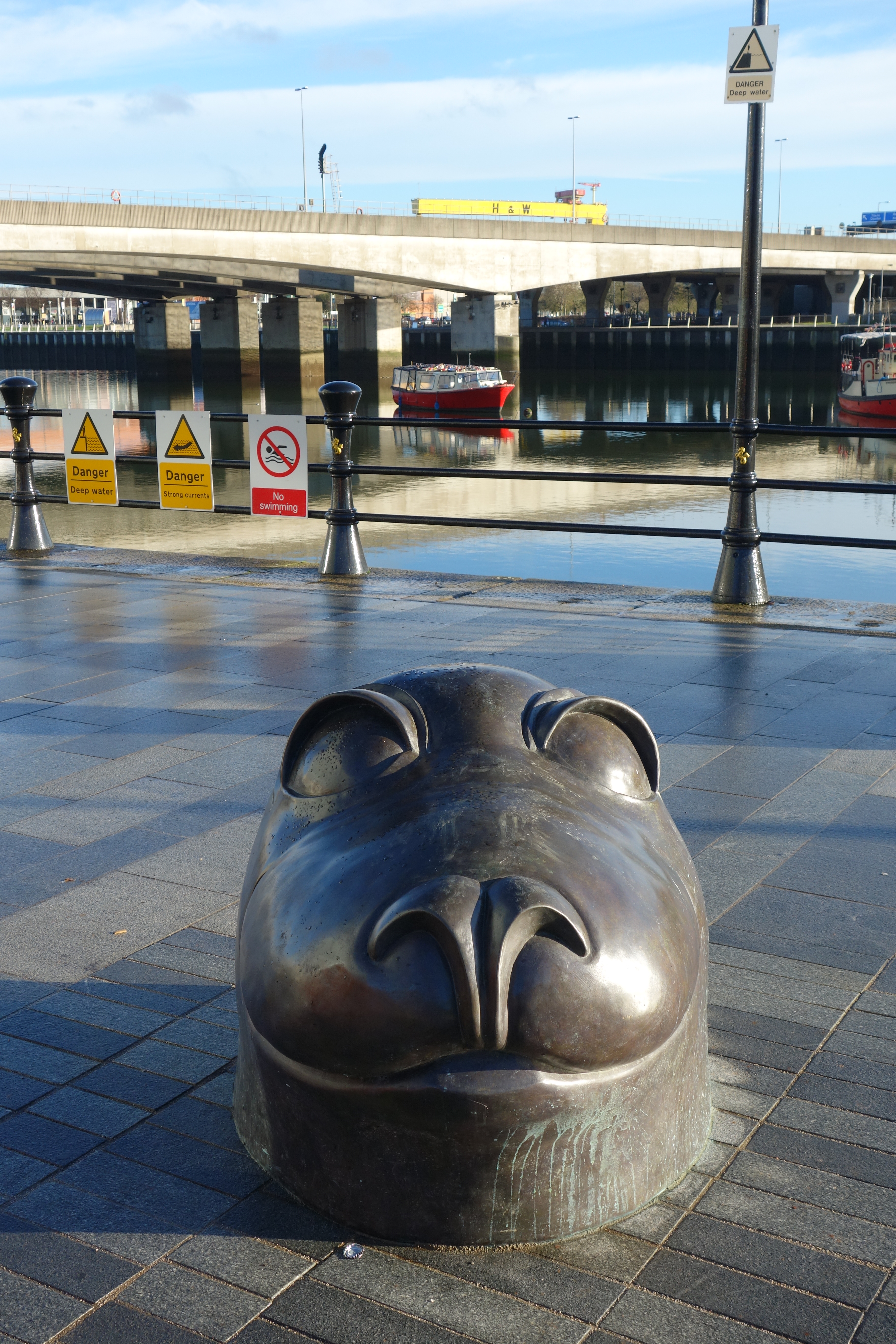
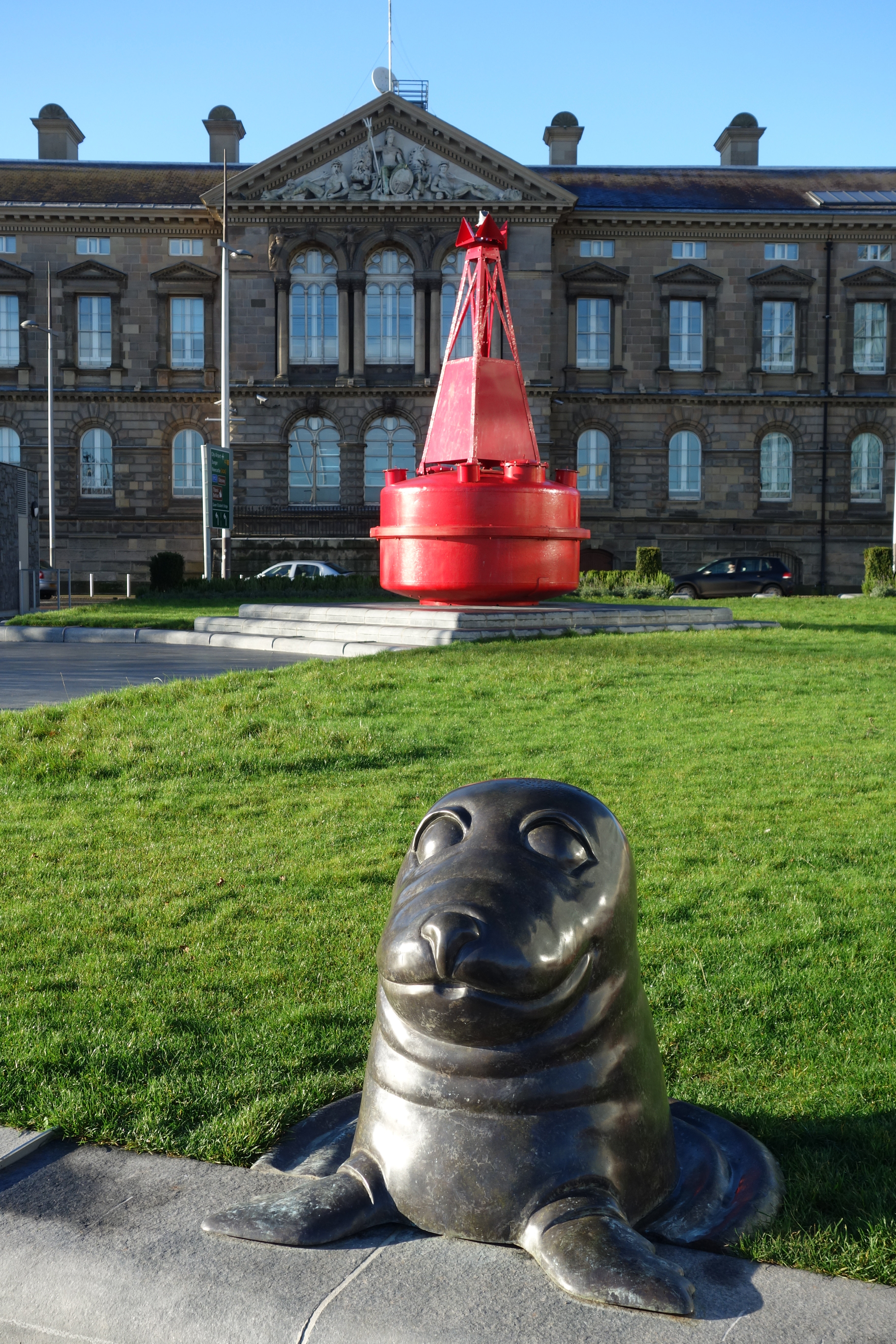
8 9

SEALS

Theres a collection of these bronze seals just across from the Big Fish. Maybe they thought it was dinner 🙂

10 11

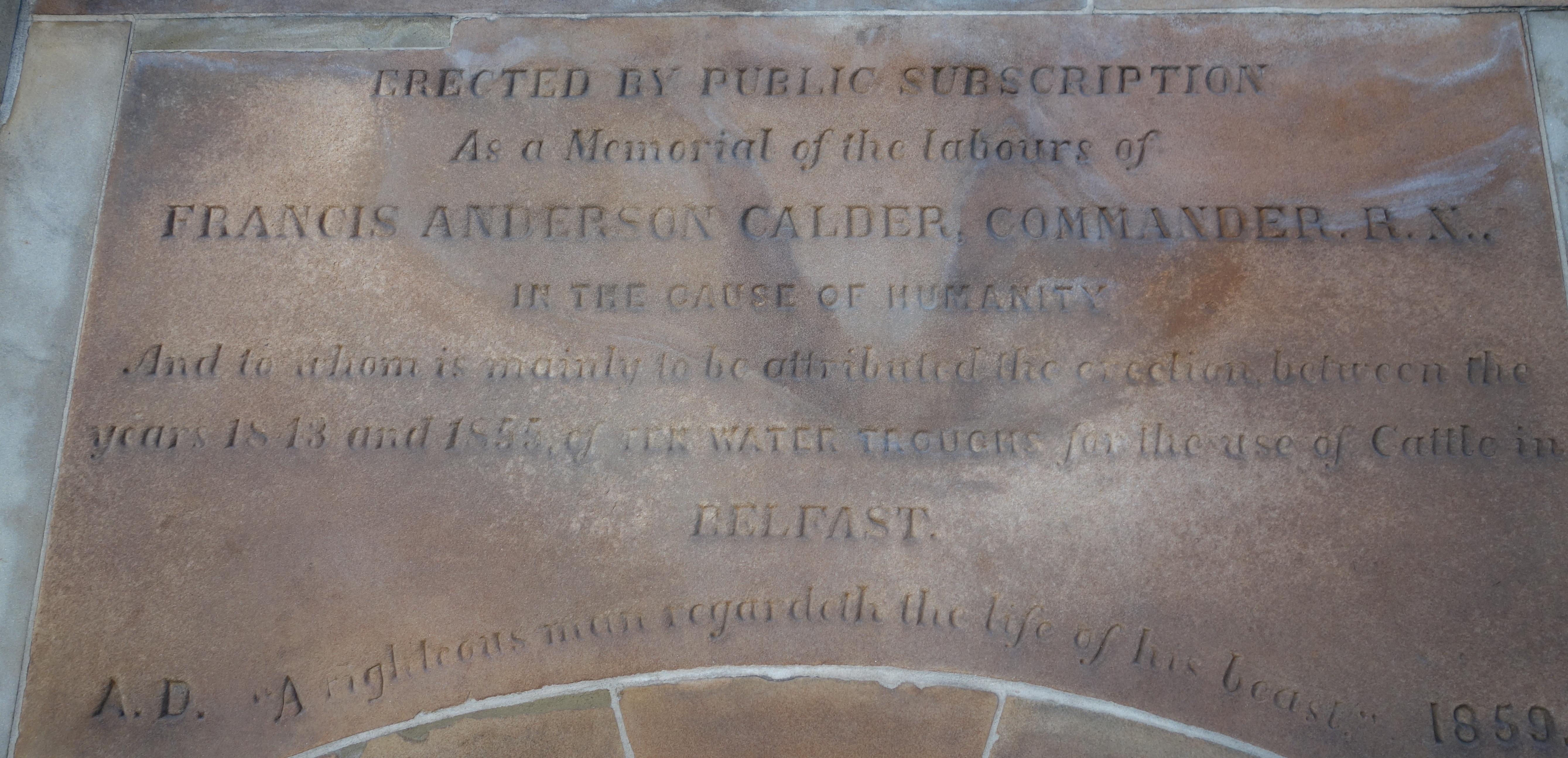
FRANCIS ANDERSON CALDER MONUMENT

Across the road from the fish, you might pass this monument by thinking its just some random memorial to a long dead political figure or something, but its actually much more endearing than that.

Erected in 1859 in memory of Francis Anderson Calder, 1787-1855. The monument is sandstone set on a granite plinth and was designed by George Smith, the Belfast Harbour Commissioners Chief Engineer. The cast iron lamp on top would have originally been gas-lit.

In 1836 Calder along with other citizens and clergymen founded the Belfast Society for the Prevention of Cruelty to Animals, later to become the USPCA (Ulster Society for the Prevention of Cruelty to Animals) which was known primarily for installing water troughs for cattle and horses in various Belfast streets. Ten troughs were installed in the 12 years prior to Calder’s death, and another eleven followed in the next eight years.

The inscription reads:

‘Erected by public subscription as a memorial of the labours of Francis Anderson Calder, Commander RN in the cause of humanity, and to whom is mainly to be attributed the erection, between the years 1843 and 1855, of ten water-troughs for the use of cattle in Belfast. A righteous man regarded the life of his beast’.
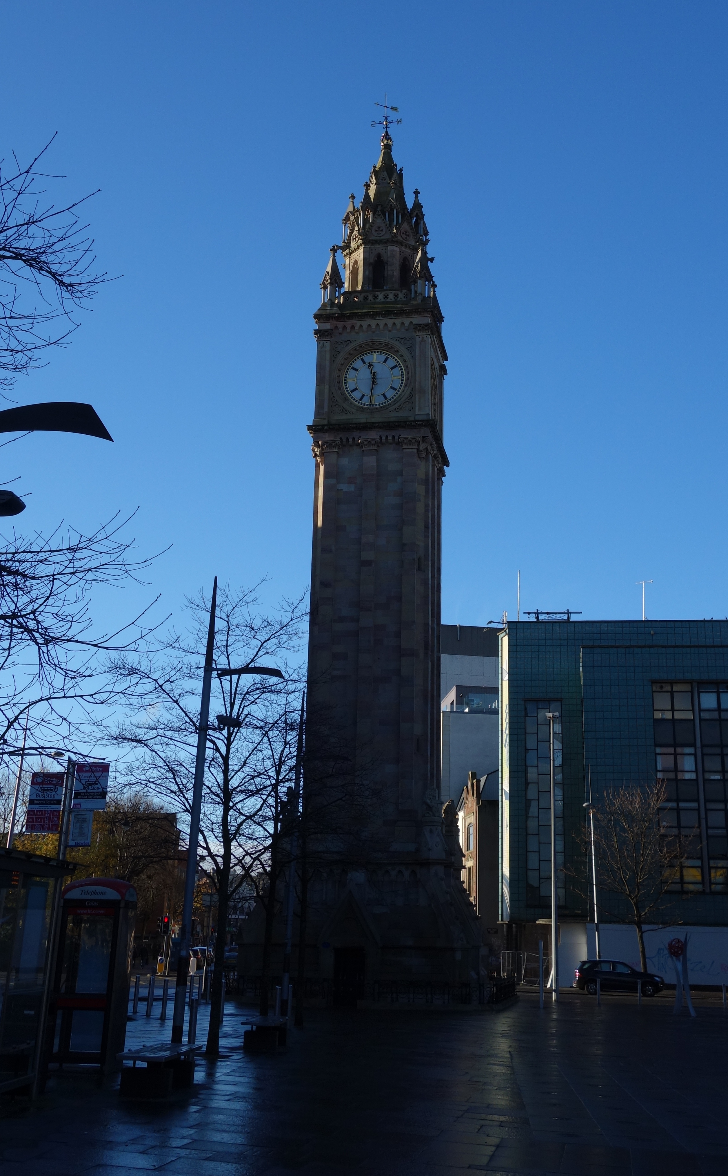
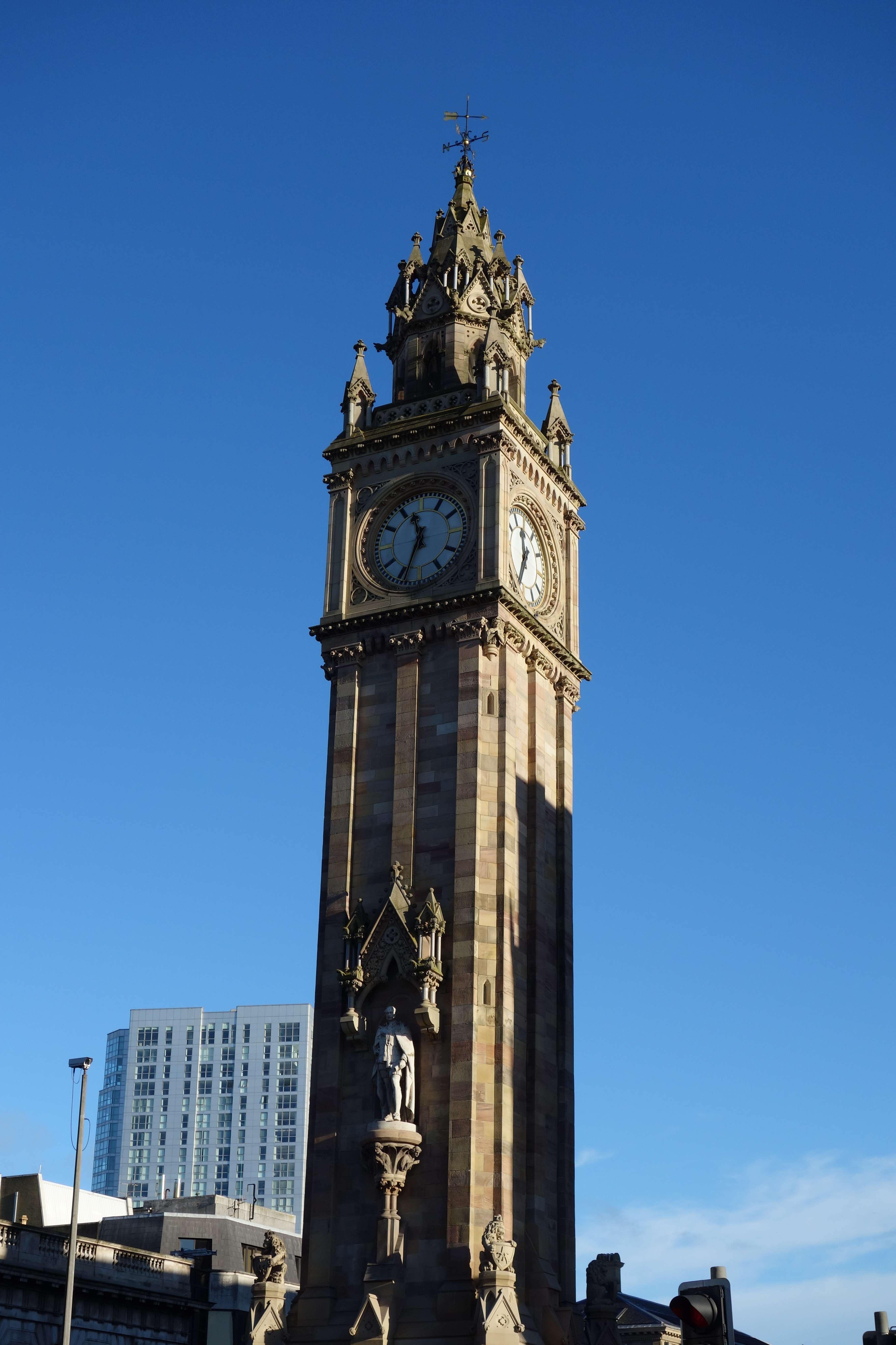
16 17 18

THE ALBERT CLOCK

The sandstone memorial was constructed between 1865 and 1869 by Fitzpatrick Brothers builders and stands 113 feet tall. The base of the tower features flying buttresses with heraldic lions. A statue of the Prince in the robes of a Knight of the Garter stands on the western side of the tower and was sculpted by SF Lynn. A two tonne bell is housed in the tower and the clock was made by Francis Moore of High Street, Belfast.

As a result of being built on wooden piles on marshy, reclaimed land around the River Farset, the top of the tower leans four feet off the perpendicular. Due to this movement, some ornamental work on the belfry was removed in 1924 along with a stone canopy over the statue of the Prince.

Being situated close to the docks, the tower was once infamous for being frequented by prostitutes plying their trade with visiting sailors. However, in recent years regeneration has turned the surrounding Queen’s Square and Custom’s House Square into attractive, modern public spaces with trees, fountains and sculptures.

In 1947, the film Odd Man Out was filmed partly in Belfast, with the Albert Clock as a central location, although neither the town nor the clock is explicitly identified.
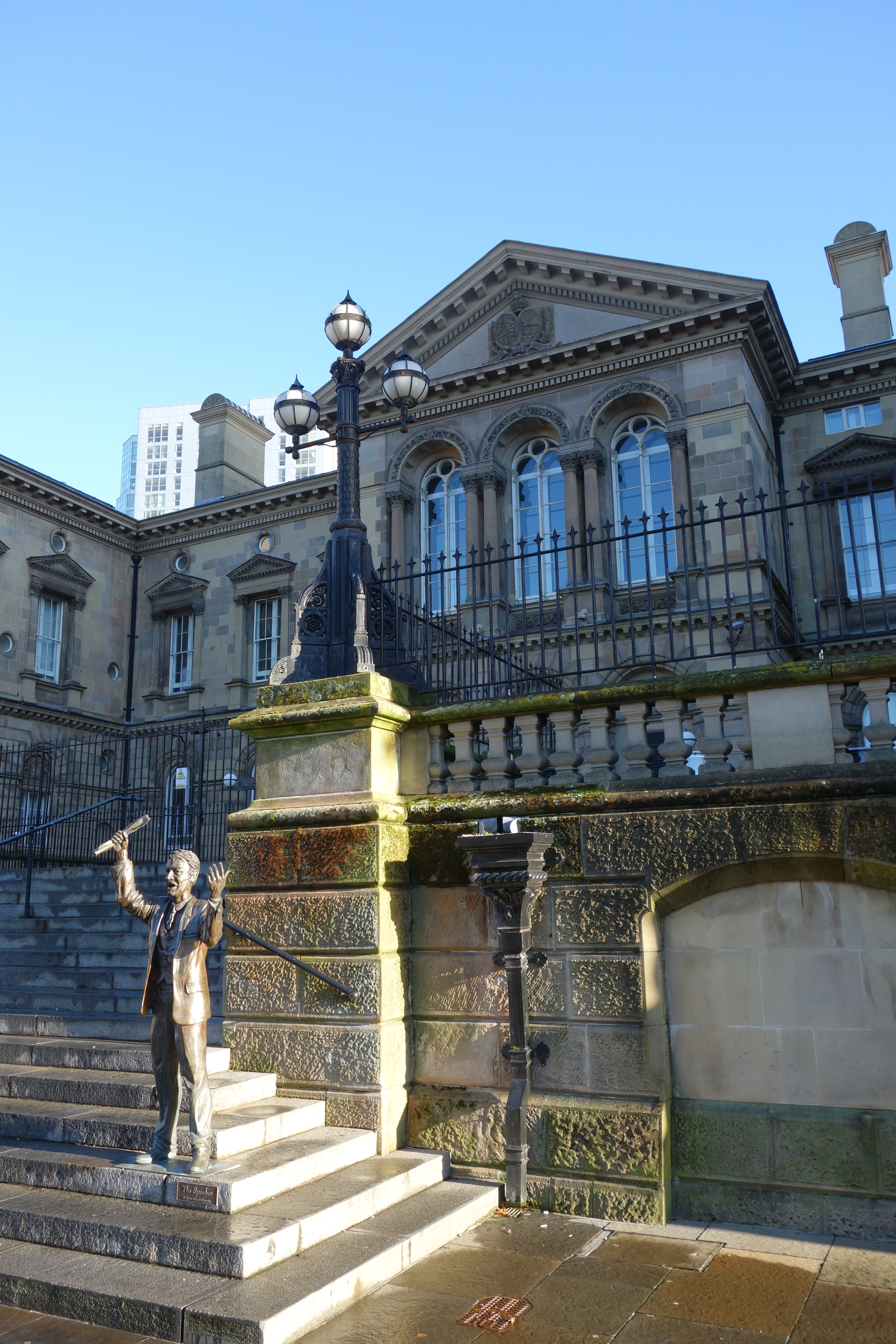
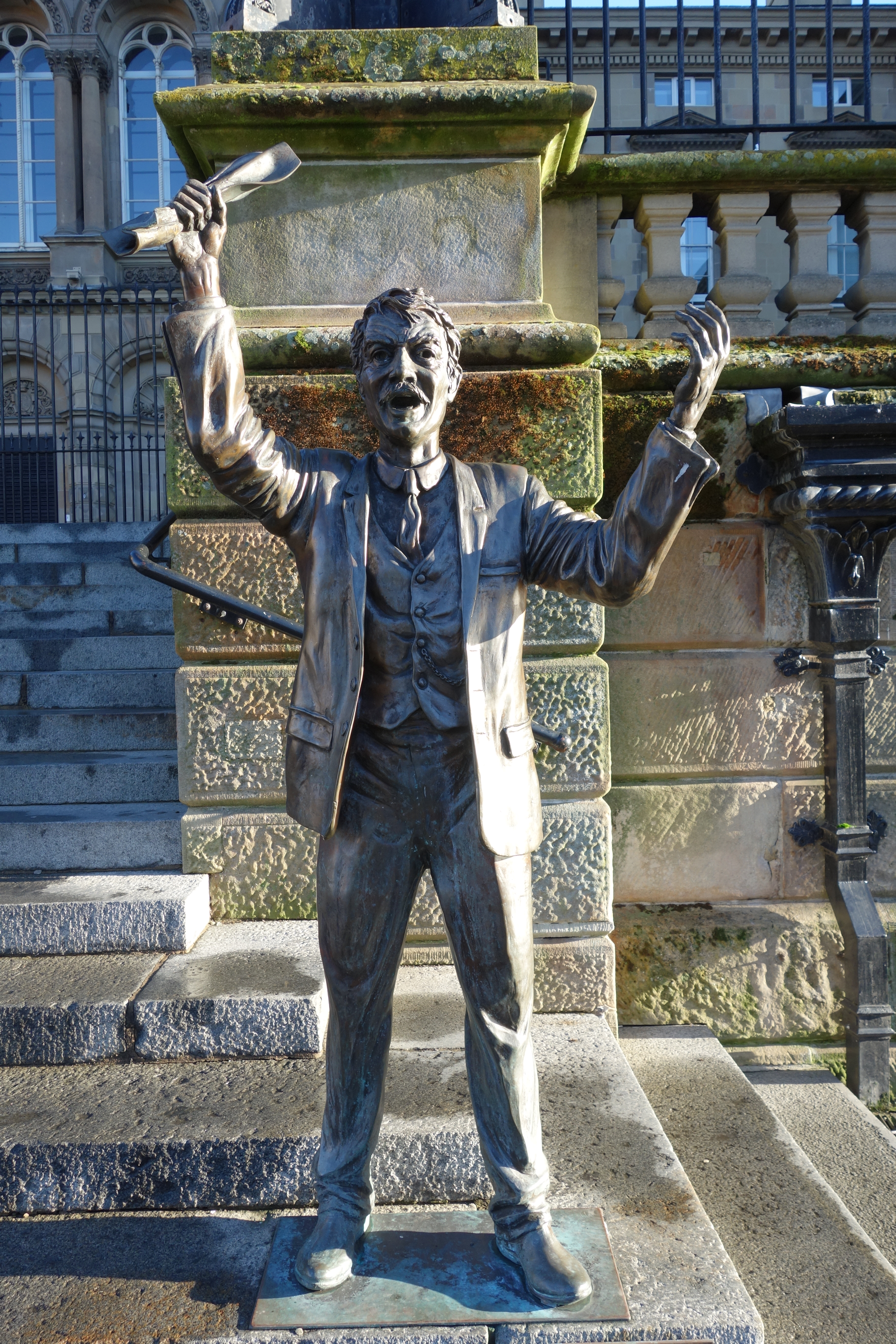
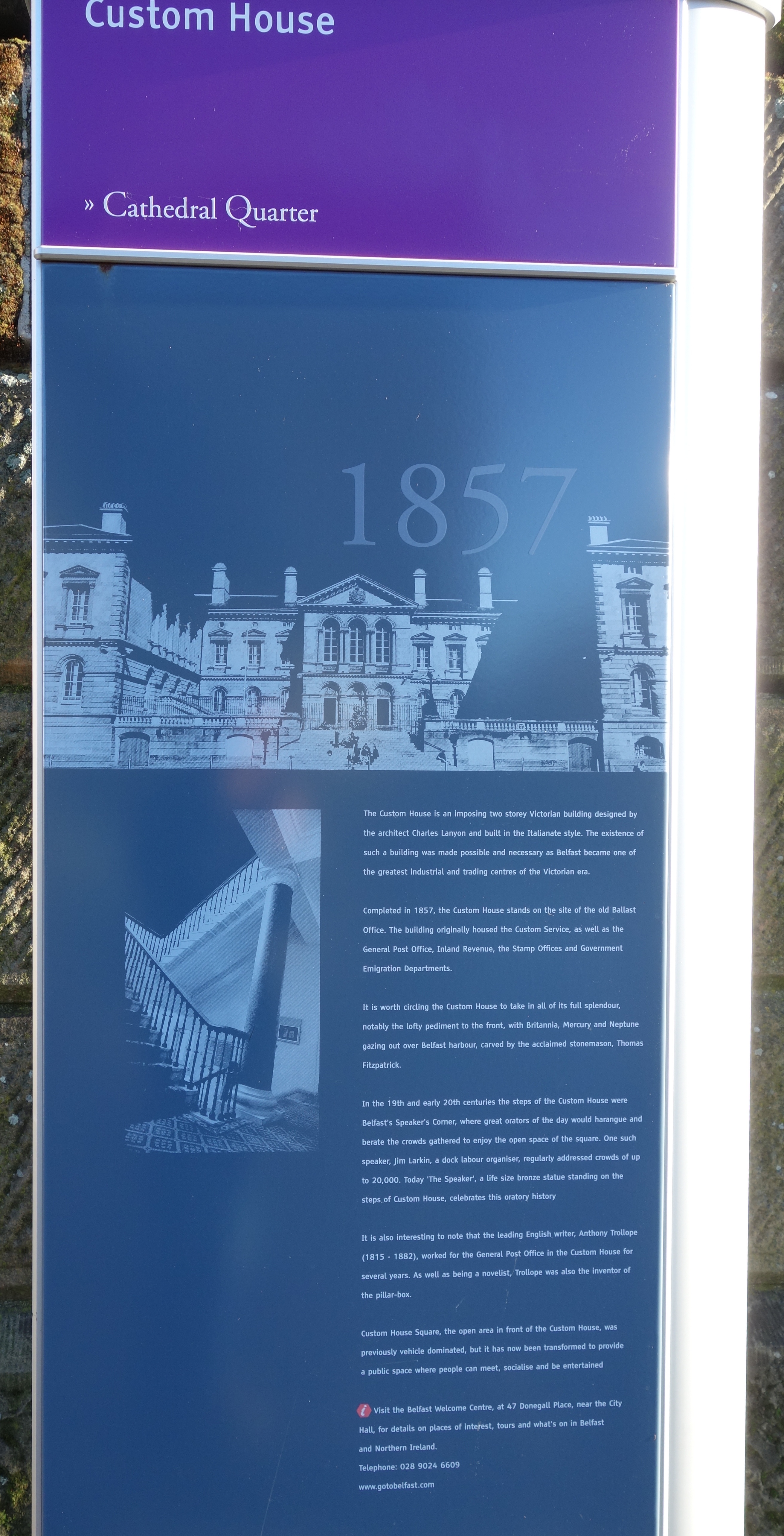
12 13 14 15

CUSTOM HOUSE SQUARE

On this bright, and final day of November 2014, there weren’t too many people around in the square (which is always fantastic when taking photos). The Customs House is an imposing Victorian building, designed by the architect Charles Lanyon, made possible and necessary as Belfast became one of the great industrial and trading centres of the Victorian United Kingdom. Only London and Liverpool collected more duty from their port than Belfast did. Belfast’s Custom House, situated on the very edge of Cathedral Quarter by the city’s central Laganside bank, was a popular site for public speakers during the late 19th and early 20th centuries. In those times, in the vein of London’s Speakers’ Corner, the city’s citizens often participated in the art of lively and spontaneous debate on any given subject. Today, in the site’s reincarnation as Custom House Square, activities can be widely varied, from more pedestrian and family-orientated performances and activities to large-scale music concerts (eg. Belsonic), D.J. performances and circus-style performance events for both adults and children. Feel free to go and shout on the steps again if the notion takes you however, as we all love a laugh here lol.

30 31 32

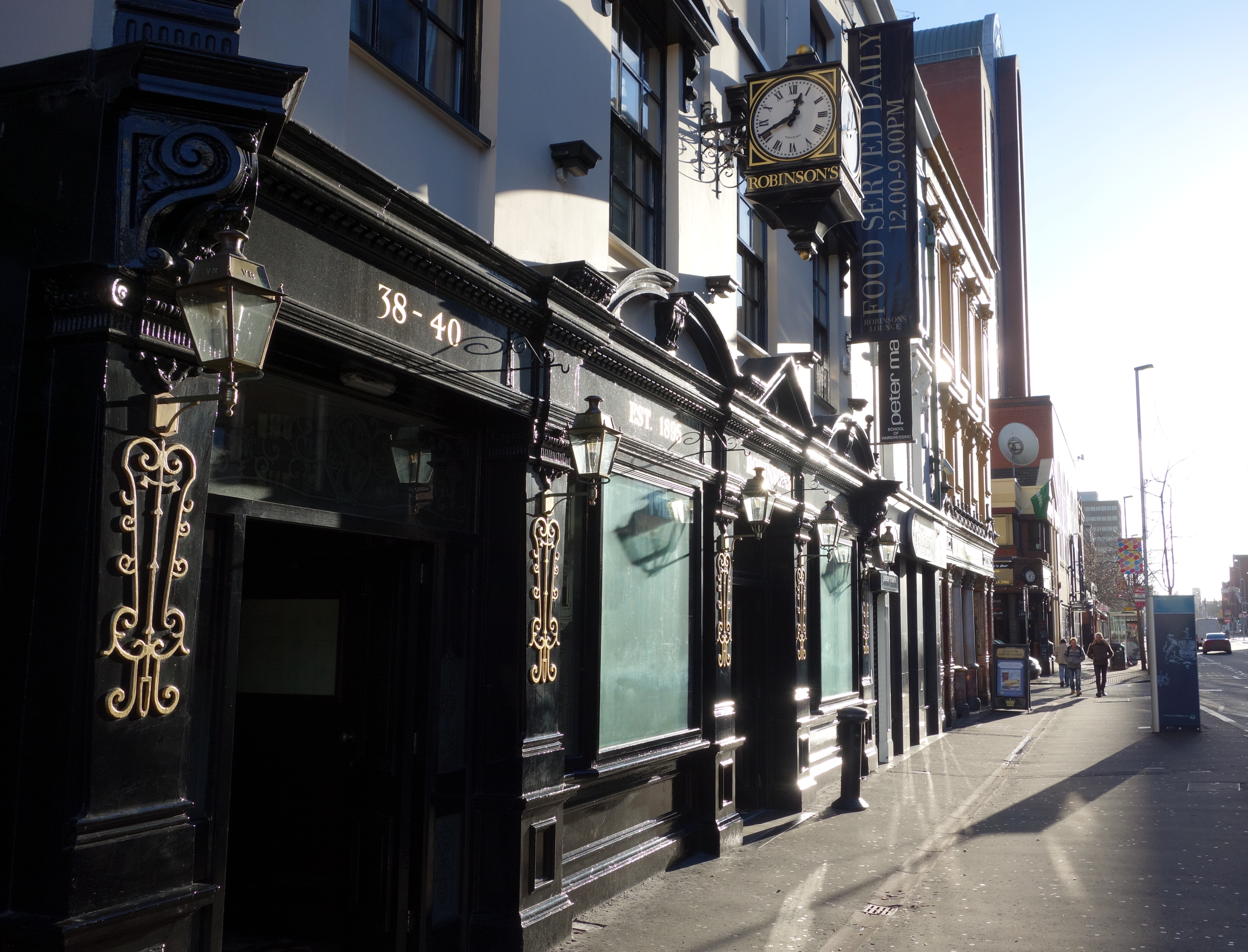
FAMOUS DRINKING EMPORIUMS

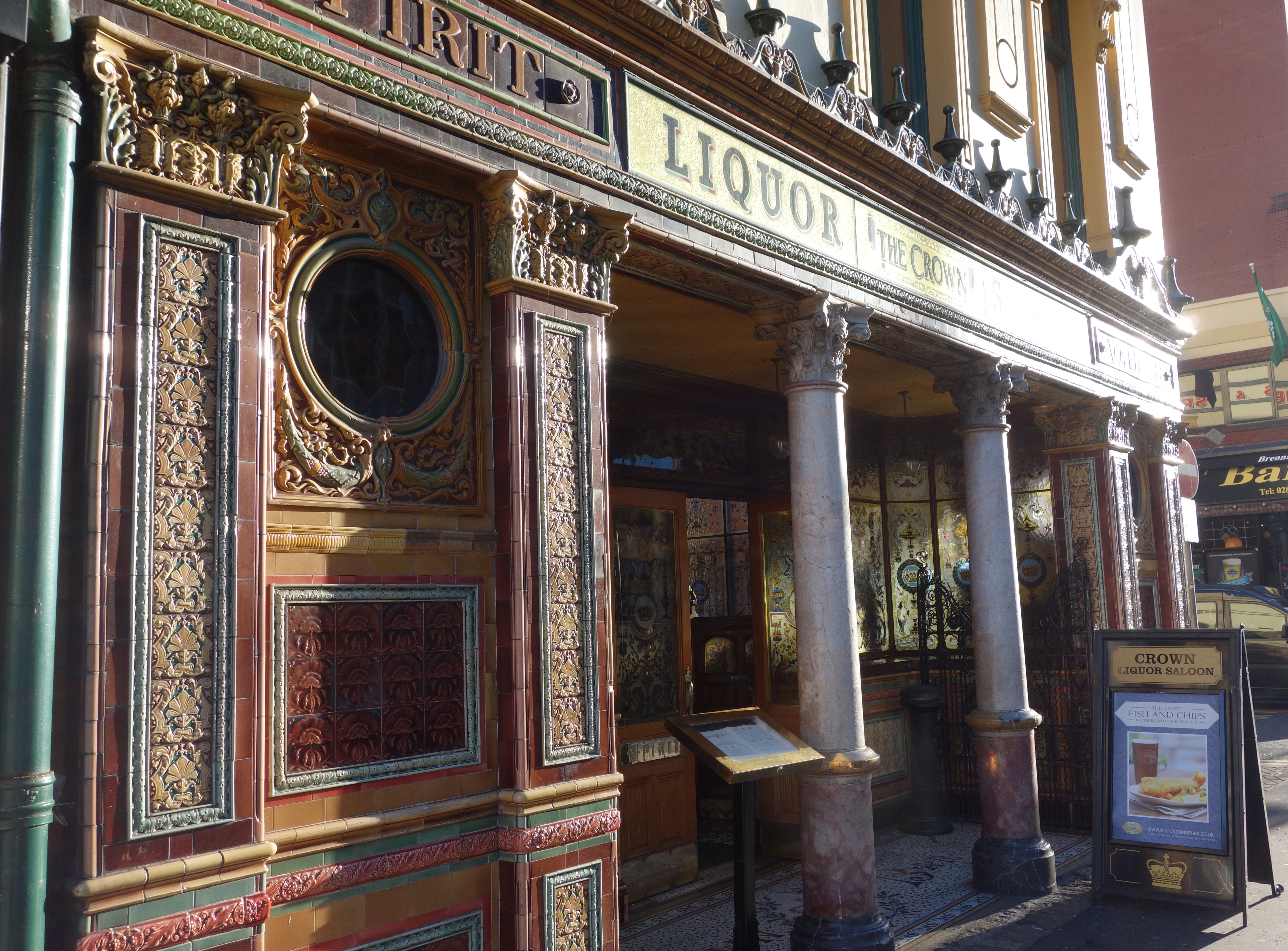
The first picture above is of Robinsons Bar (aka as “Robbies”) on Belfasts Great Victoria Street (across the road from The Europa Hotel). Its next door to the quite famous Crown Bar which draws many tourists and its history is below (thanks to Wiki)..

Originally opened by Felix O’Hanlon and known as The Railway Tavern, the pub was then bought by Michael Flanagan. Flanagan’s son Patrick renamed and renovated the pub in 1885.

The Crown owes its elaborate tiling, stained glass and woodwork to the Italian craftsmen whom Flanagan persuaded to work on the pub after hours. These craftsmen were brought to Ireland to work on the many new churches being built in Belfast at the time. It was this high standard of work that gave the Crown the reputation of being one of the finest Victorian Gin Palaces of its time.

In 1978 the National Trust, following persuasion by people including Sir John Betjeman, purchased the property and three years later completed a £400,000 renovation to restore the bar to its original Victorian state. Further restoration by the National Trust was done in 2007 at a cost of £500,000.

A recognisable landmark of Belfast, the pub has featured as a location in numerous film and television productions, such as David Caffrey’s Divorcing Jack (1998) and as far back as Carol Reed’s 1947 film Odd Man Out.

The Crown has been given a Grade A Listed Building status by the Environment and Heritage Service. The exterior is decorated in polychromatic tiles. This includes a mosaic of a Crown on the floor of the entrance. The interior is also decorated with complex mosaics of tiles. The red granite topped bar is of an altar style, with a heated footrest underneath and is lit by gas lamps on the highly decorative carved ceilings. The Crown has ten booths, or snugs. Built to accommodate the pub’s more reserved customers during the austere Victorian period, the snugs feature the original gun metal plates for striking matches and an antique bell system for alerting staff. Extra privacy was then afforded by the pub’s etched and stained glass windows which feature painted shells, fairies, pineapples, fleurs-de-lis and clowns.
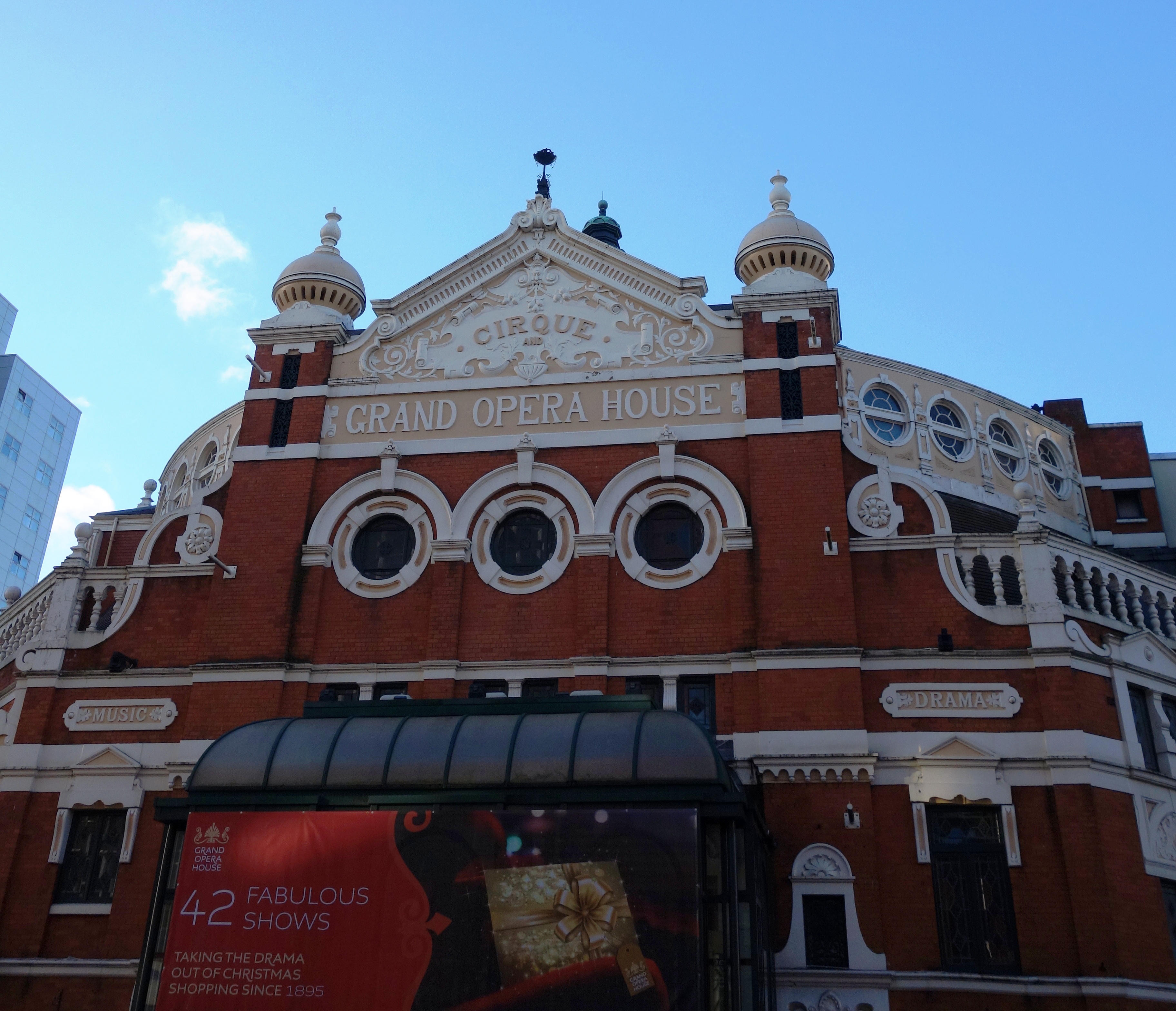
29

GRAND OPERA HOUSE

The Grand Opera House is a theatre in Belfast, Northern Ireland, designed by the most prolific theatre architect of the period, Frank Matcham. It opened on 23 December 1895. According to the Theatres Trust, the “magnificent auditorium is probably the best surviving example in the United Kingdom of the oriental style applied to theatre architecture” The place is a huge hit all year round with both locals and tourists. With the Christmas period upon us there are many shows on now and coming soon. See here: http://www.goh.co.uk/

26 25

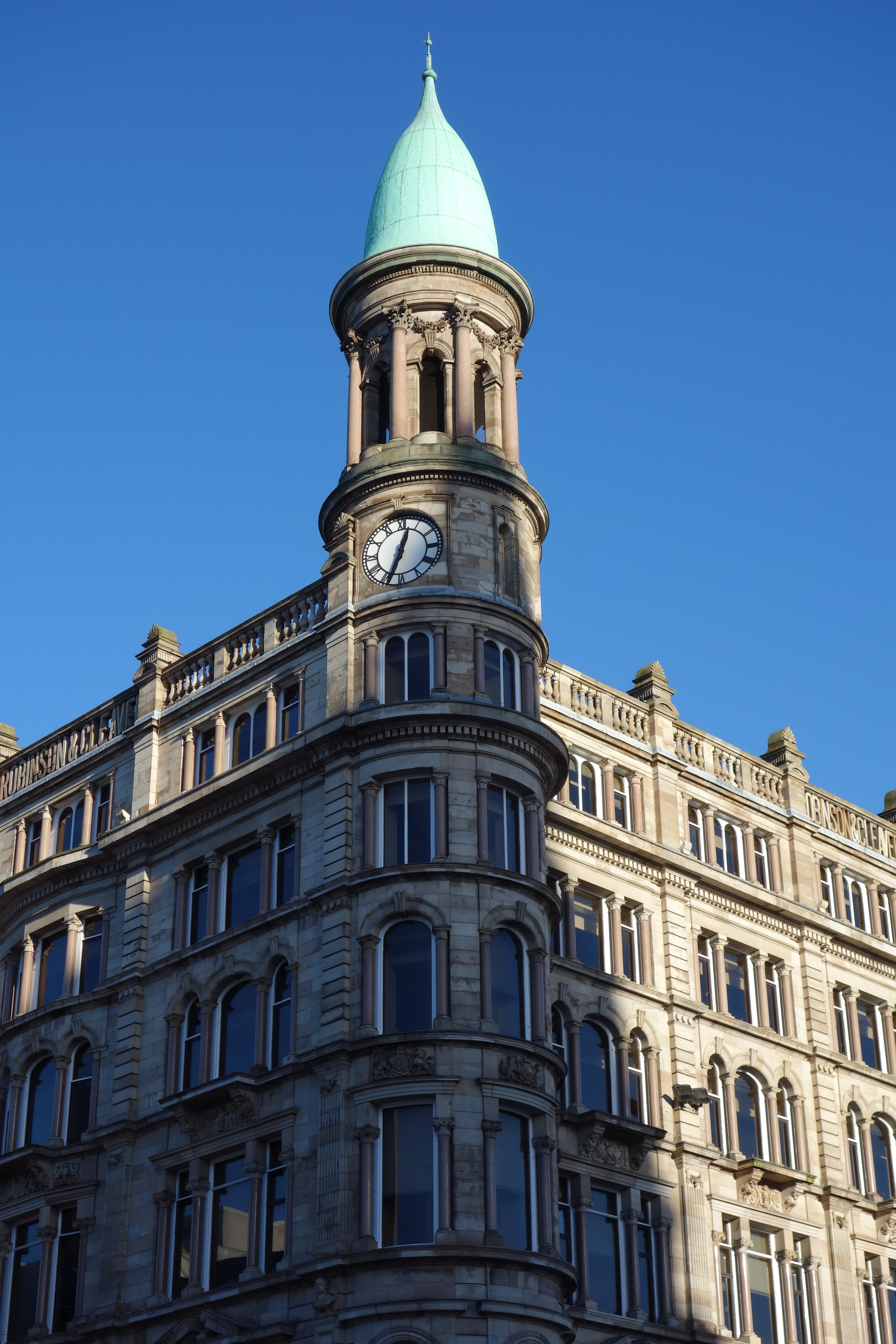
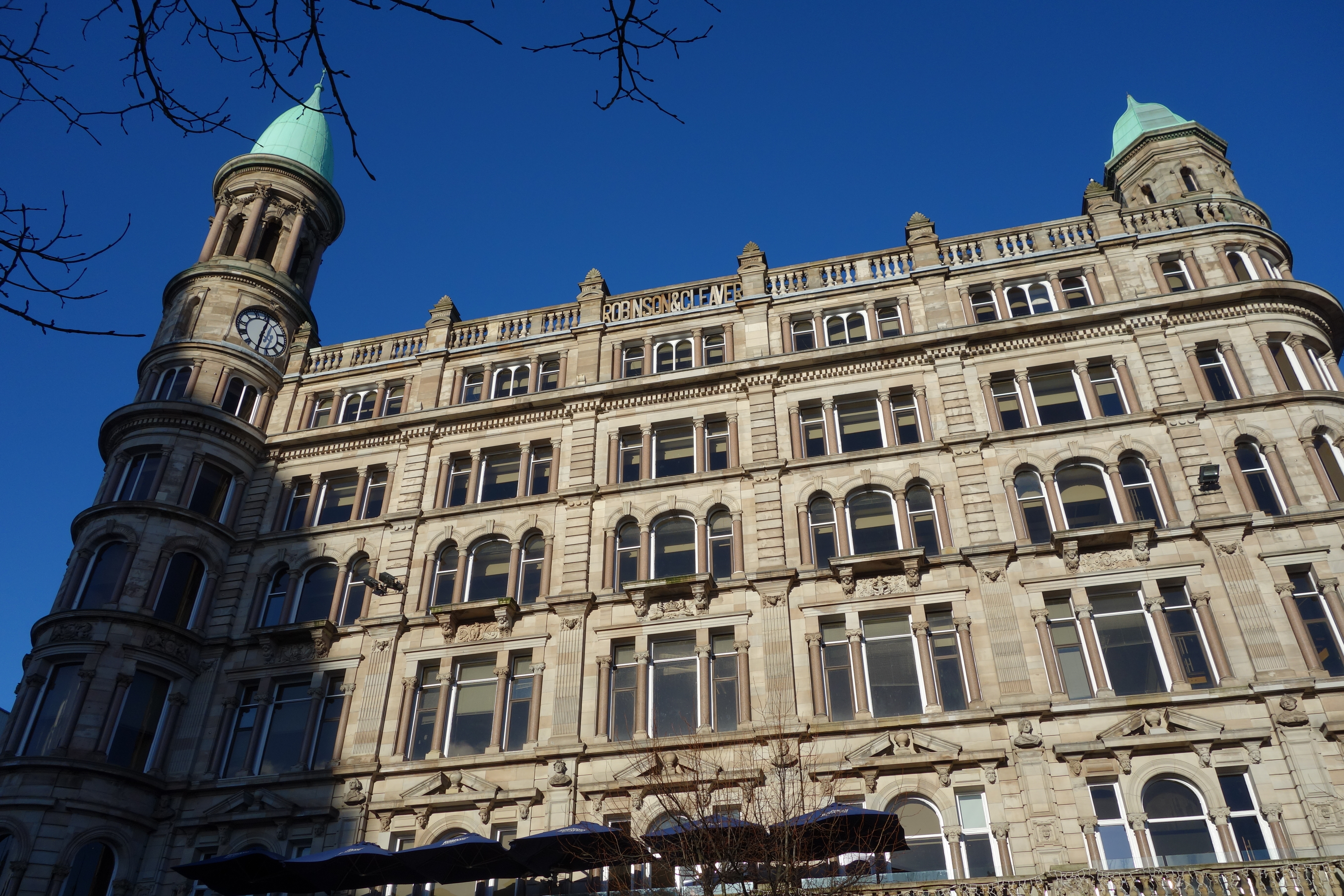
ROBINSON CLEAVER BUILDING

Without doubt, there are many ornate and beautiful buildings in Belfast if you just look upwards. This is one of them. On a wonderfully clear day like today the Robinson and Cleaver building could easily fit around New Yorks Central Park area and not look out of place.

Robinson and Cleaver, at the corner of Donegall Place and Donegall Square North, became a top department store in Belfast after opening in the late 19th century, and bore such connotations of grandeur that it was known as ‘The Old Lady’. It was a classy place to visit, where staff knew their usually wealthy clientele. Its most famous feature was a marble staircase, auctioned in 1984. Robinson and Cleaver prided itself for being the most famous store in the world for Irish Linens. In 1921, it also advertised…. “We are making a Special Show of our New Season’s Models in all the latest shapes in Fur Coats, Wraps, Stoles and Collars in Skunk, Skunk Oppossum, Beaver, Beaver Coney and Real Moleskin. Animal Ties in White, Black, Grey, and Blue Foxes; also in Mongolian Fox and Blue Wolf. Only the most reliable quality of Furs are stocked (dont expect to find too many of those in Belfast now haha). Despite extensive renovations in 1963, Robinson and Cleaver closed down in 1984 and its famous staircase was auctioned. Today, having reopened with several shops inside, it has a marvelous cafe upstairs with outdoor seating looking directly across to the City Hall. Well worth checking out. You can just about see the parasols of the cafe in the second picture here.

19 20

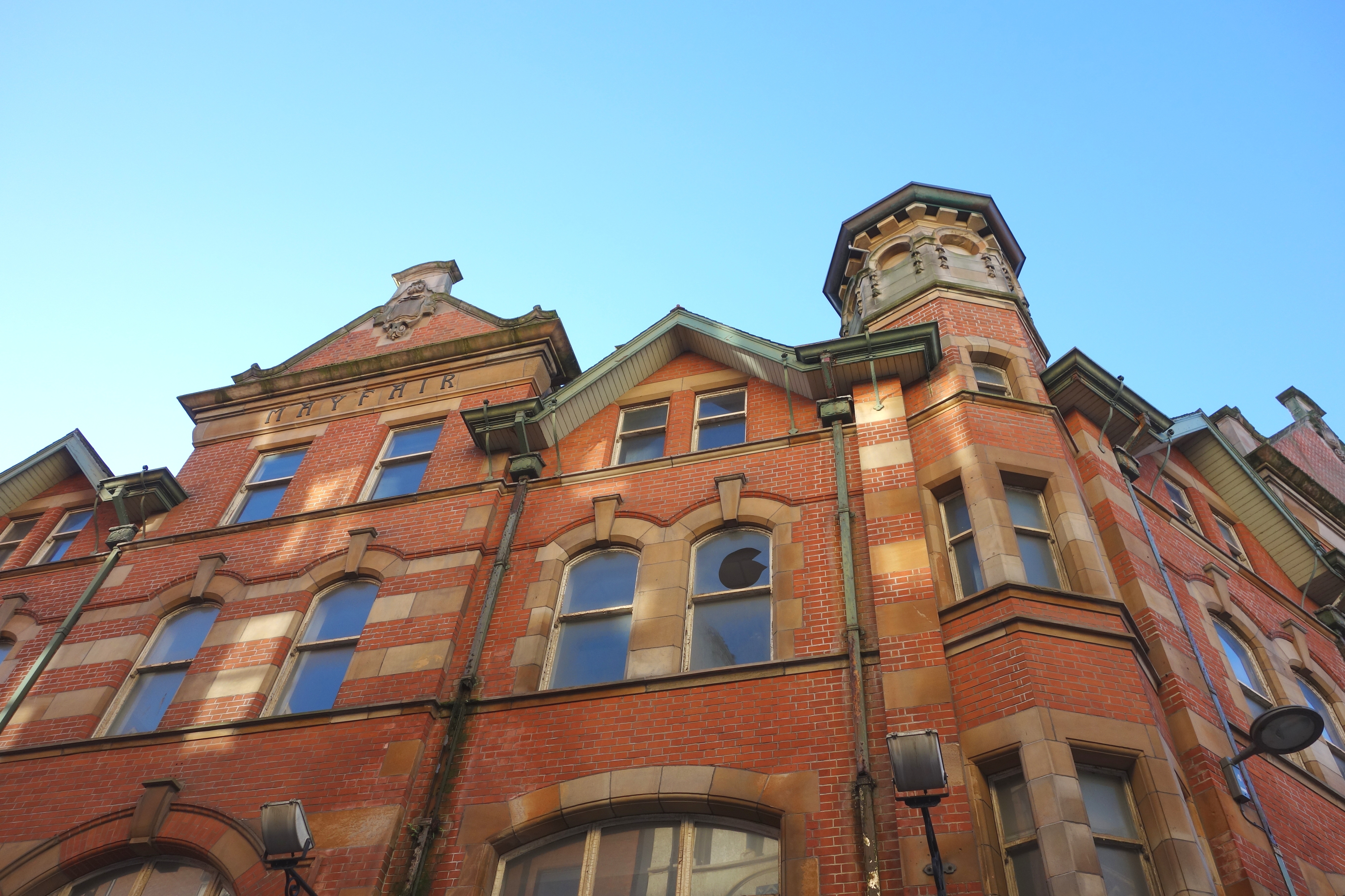
NATIONAL BANK BUILDING & MAYFAIR BUILDING

Another two lovely buildings you really might not notice unless you lifted your head a little above the pavements of the shopping areas of Belfast. The first is the National Bank Building (looking quite impressive in the Winter sun here)…

A five-storey painted terracotta and red-brick building built 1893 – 1897 by William Batt for the National Bank. The National Bank operated from the concrete and steel framed building until being taken over by the Bank of Ireland in 1966. The buildings exterior survived largely intact until the ground floor was re-clad and a small central balcony was removed in the 1980’s. In June 2013 a £700,000 project began to redevelop the ground floor for use as a a cafe / bar. The ‘National Grande Café Bar’ opened in September 2013 alongside a new “artisan” bakery and patisserie in the adjacent building. In February 2014 a planning application submitted by Cathedral Leisure Ltd (Beannchor Group) proposed fit-out works to upper floors of the building to provide additional accommodation for the existing ground floor public bar.

Hmm….. I’m not sure about you but it always seems a shame to me when I see these old buildings reduced to the levels of a cafe etc, but I suppose if it saves the building by giving it a new purpose then that has to be good.

The second picture is of the Mayfair Building in Arthur Square, Cornmarket. This is right bang in the city centre. I havent been able to find out much about it online (feel free to update me here) with the following all thats apparent….

The Mayfair Building: At 5-11 Arthur Square is a four storey red brick building designed by Blackwood & Jury with gingery sandstone detailing including banded quoins. Art noveau detailing at the capitals of pilasters divide the shop units.
The upper floors of the building remain vacant some years after the Belfast Gas Company moved out.

This information is likely quite old, but the building sits overlooking the square at Cornmarket with the (ugly) metal structure sitting in front of it. I have to say, the old Cornmarket with the red bandstand and clock looked better than that monstrosity they have there now. See here:  http://cain.ulst.ac.uk/images/photos/belfast/cornmarket2.htm

23 27 28

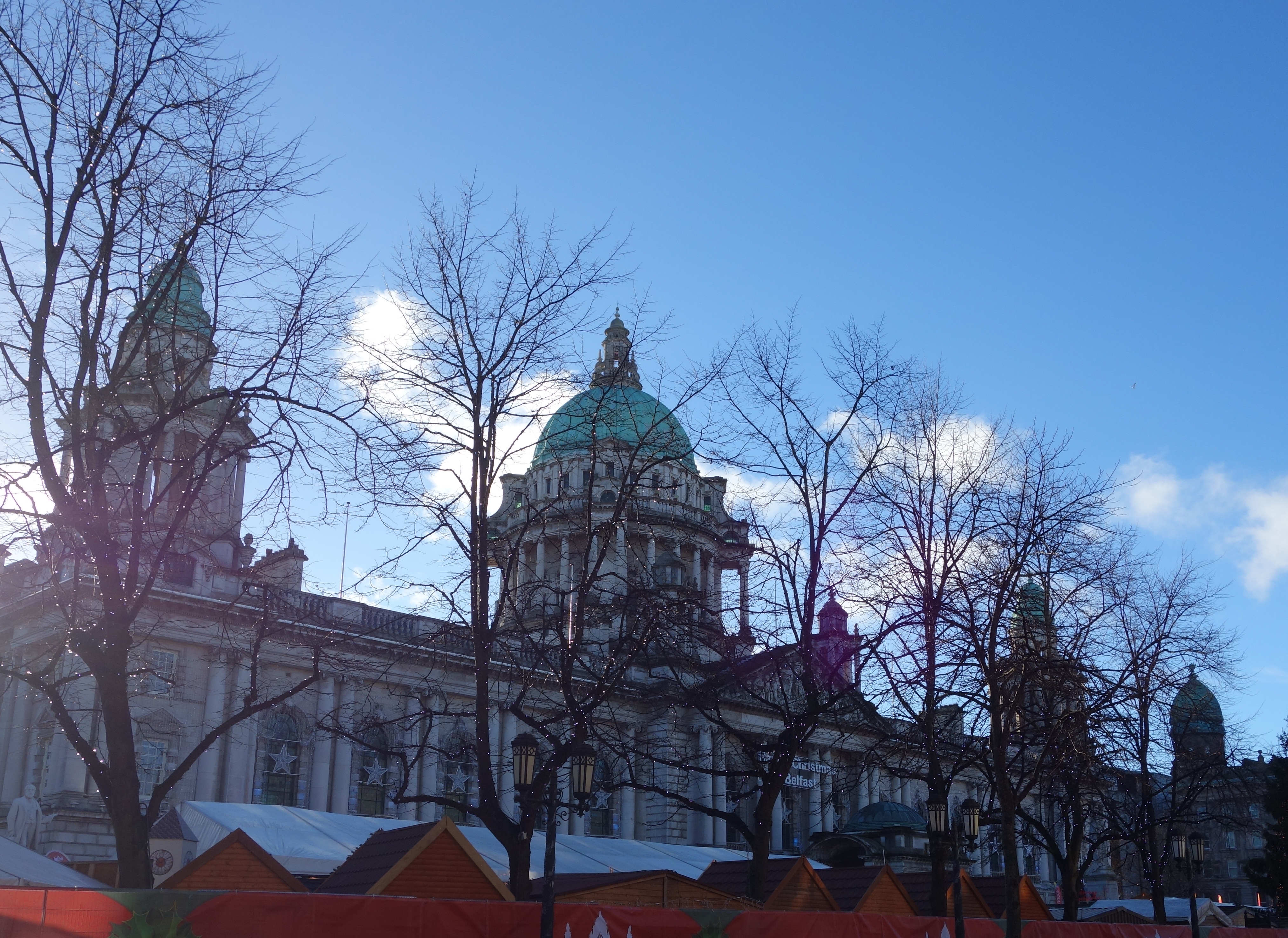
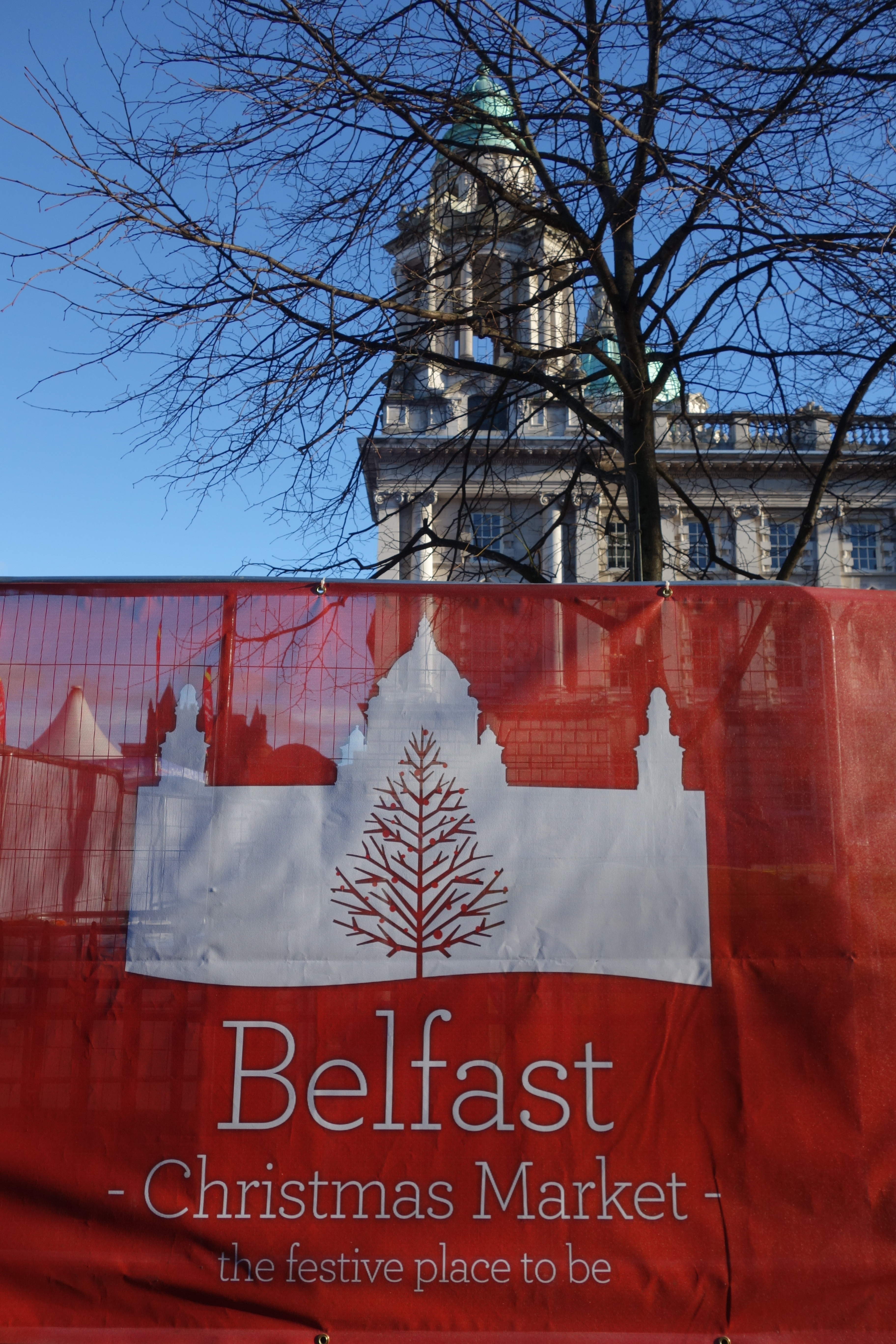
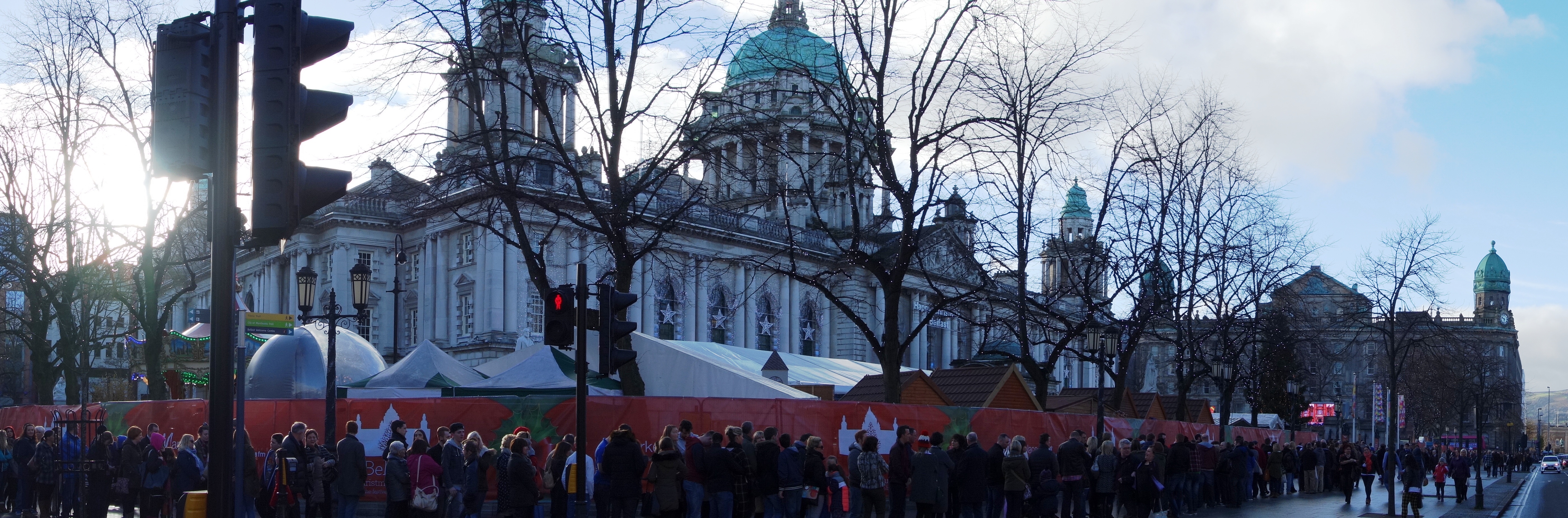
BELFAST CHRISTMAS MARKET 2014

Ok, getting to the market, or should I say NOT getting to the market. We arrived into Belfast pretty early on Sunday the 30th November at about 11am where I took all the photographs above. Like I said at the start of this post, the idea was to visit the Christmas market (and get some pix inside). But heres a tip, while the market is busy everyday on the run up to Xmas, it looks as if Sundays are the absolute worst day to go. Why? Because due to our ridiculous opening laws (don’t get me started on this nonsense) nothing here (larger than a certain size) is allowed to open until 1pm on a Sunday (if you didn’t know this already you can pick your jaw up off the floor now) so what happens is, everyone starts queuing to get into the market about 1215 and rather than a steady stream of visitors spread over the day, everyone tries to get in at once. The result? A queue that starts at one side of City Hall and loops three-quarters of the way around it. Hundreds and hundreds of people lining up to get in. Like I said, I don’t want to start spouting off about these Dark Age, faith created laws, but it certainly looks as if the general public couldn’t care less about them and want them changed. Even if a Sunday falls a day or two before Xmas the shops still aren’t allowed to open until 1pm. Would this happen in any other European and modern, city? No way.

Anyway, I hope to get a few more pictures of inside the market before it closes for the Xmas season of 2014, but for now, picture one shows Belfast City Hall (with the tops of the Xmas market kiosks) on Nov 30th 2014, picture two is a little shot of the red wrapping for the market around the hall railings. And picture three is a panoramic shot of the queue to get in before 1pm on Nov 30th 2014 (believe me, this doesn’t show it all and there just wasn’t any way we were standing in that). The gate staff only allowed a certain number in at a time, and given our stupid Sunday laws everything must also close at 6pm so I imagine many didn’t get in that day at all. So remember folks, God says thou shalt not eat German spicy sausage or drink mulled wine outside the hours of 1-6pm while in Northern Ireland on a Sunday. I think its the 11th Commandment or something 🙂

Creightons Woods, North Down, County Down

Having lived in this area for over 10 years now, it came as a bit of a surprise to go for a drive a few days ago and discover a place Id never seen before, literally 15 minutes from my home. Theres almost nothing about Creightons Wood on Google in terms of information or location, and judging by the condition of the place it seems as if it doesn’t see many visitors these days. The sign at the entrance is badly rotting, and many of the trees have fallen over and are diseased. Such a shame, as on this mild November morning I had the whole place to myself and didn’t see any wildlife in there, not even a bird (which felt slightly weird!). The woods are hundreds of feet above sea level (which is at Belfast Lough below). As the wind blew that morning it made an eerie wailing noise through the trees, really fantastic stuff. There were many varieties of mushroom growing there too, none Id take a chance on eating however, as I’m not at all educated on all things fungi. But I hope to visit this abandoned and melancholy place again soon.

CREIGHTONS WOOD NOV 14 (1)

The old sign into the woods. An old poster of a lost dog remains stuck to one leg of it. I wonder was he ever found?

CREIGHTONS WOOD NOV 14 (3)

Trees tower high into the November sky. Not a sound but the wailing wind.

CREIGHTONS WOOD NOV 14 (2)

Many trees have fallen over a long time ago it seems. Leaving big pools of dark water where their roots used to be.

CREIGHTONS WOOD NOV 14 (4)

Strangely, parts of the woods seemed to be flourishing too however, with a stream here bursting with green leafy life even at the edge of an oncoming Winter.

CREIGHTONS WOOD NOV 14 (5)

Another tree sits precariously after falling, and a green blanket of moss covers the foreground in Creightons Wood.

CREIGHTONS WOOD NOV 14 (7)

A circle of mushrooms.

CREIGHTONS WOOD NOV 14 (8)

Picture taken from the top of a big mushroom.

CREIGHTONS WOOD NOV 14 (9)

A fungi giant. If I had know he was edible I would have taken him home.

CREIGHTONS WOOD NOV 14 (6)

Looks like someone in the past had placed a piece of old picket fence to cross the stream.

CREIGHTONS WOOD NOV 14 (11)

The roots and base of a fallen tree looks like some creepy witch figure here.

CREIGHTONS WOOD NOV 14 (12)

No, not a six foot long piece of broccoli, but a little fallen tree covered in moss.

CREIGHTONS WOOD NOV 14 (10)

Flooded land at Creightons Wood. November 2014.