A Summer Sunrise at Seahill (video).

Well, I havent been here for such a long time, almost a year in fact, so I thought Id put up a small video I made of very close to where I live. It was filmed early one Summers morning a few weeks ago, on the shores of Belfast Lough, at Seahill County Down. Its not a part of the lough shore that a lot of people flock to (its neighbours Helens Bay and Crawfordsburn get all the crowds) but its a peaceful area that the locals really enjoy (theres also some great blackberry picking at this time of year). The music here is by Ceeys and the track is called Hiddensee.


Dundrum Castle, County Down.

Thought to have been built around 1177, Dundrum Castle was part of the coastal defences controlling land routes from Drogheda to Downpatrick. Its just up a hill from the village centre of Dundrum and access is free (which is always great).  Dundrum is on the main road to Newcastle and if you wanted to kill two birds with one stone it has a decent car boot sale on Sundays but its better when the weather is good (summer being best of course).

dundrum castle (29)

On the morning I arrived there was a pretty thick fog hanging over Dundrum Bay below the castle, but because it sits on a hill you could actually see over the top of the fog. You can see the town church spire poking up through the mist here.

Parts of the castle ruins look more like parts of an old house but I think there were numerous additions to the original castle down the centuries.  As the fog started to burn off I got some nice pictures of the place.

The tower set at the back of the castle grounds. The second picture shows the view through one of the windows of the tower over Dundrum Bay below.

dundrum castle (24)

The castle wall remains.

dundrum castle (58)

There are some woods to the left hand side of the castle (known as Castle Woods) that have a nice walking trail through them (seen just behind the fence here). The woods were planted nearly 200yrs ago and some information on them can be found here if youre interested: http://www.walkni.com/walks/382/dundrum-castle-woods-trail/ I had a great little morning (which as you can see turned out really beautiful) and an early visit like this (my first time) was certainly worth the trip.


Random Stuff! Here & There.

This is just a few pictures I had lying around on my computer that Ive taken over the last year or two. I didnt have enough of each location for a full post (on the place) so Im just gonna dump them individually here. All pics are of course coming from Northern Ireland and as ever, are taken with a compact camera only 🙂


newcastle (4)

Early morning spiders, taken at Murlough Bay, near Newcastle Co.Down, a few weeks ago.

seahill (1)

Tranquility at Seahill. Only about 15mins walk from the beach at Helens Bay, but things are much quieter here and actually rather nice.


seahill (25)

Just a tree and high flying birds on a grey morning. Taken around about Craigavad (between Seahill and Cultra) County Down.


portrush 16th may 2018 (18)

Big Dipper reflections…


wateresk (6)

There are many dolmen (portal tombs) scattered around Northern Ireland, and several seem to be on farmers land. This is “Wateresk” which is right in the middle of a farmers field between Dundrum and Newcastle.

seahill (28)

A snail. Outside my house. Outside his house.

Rostrevor & Cloughmore Stone, Co. Down

Cloughmore Stone, known locally as “The Big Stone” is a huge granite boulder that sits about 1000ft up on the side of Slieve Martin overlooking Carlingford Lough and the Cooley peninsula in County Louth and above the village of Rostrevor County Down.


rostrevor (18)

The name comes from the Irish “an Chloch Mhór” which means “the big stone” and its believed to weigh around 50 tonnes having been transported via glacial retreat from Scotland  (from an island in Strathclyde bay) and deposited here over 10,000yrs ago during the last Ice Age.


rostrevor (22)

Local legend has it that the stone was thrown from the Cooley Mountains on the other side of Carlingford Lough, by the giant Fionn mac Cumhaill (Finn McCool) who gets accused of a lot of things here in Northern Ireland haha (Lough Neagh, The Giants Causeway etc).


rostrevor (20)

The stone has many names and dates carved into it which go back centuries remembering those from history who have visited there. The Cloughmore Stone is a venue at Easter where the residents of Rostrevor would go up and roll their Easter eggs down the hill. A sort of a tradition for the Rostrevor residents.


rostrevor (31)

Quite impressive even on a rainy day like this one and there are some great views from the surrounding area.


rostrevor (29)

Theres a really nice walk up here through Rostrevor forest but it does get steep at times. Bring a lunch and rest at the top.


rostrevor (25)

Autumn around County Down

I’m a bit late putting these up as Winter is well and truly upon us but having found them on my camera I thought Id stick them here as a reminder of Autumn 2016 which has left us for ever.

Picture 1: Queens University Belfast, Picture 2: The Ulster Museum (Botanic Gardens), Picture 3: Palm House (Botanic Gardens).


Picture 1: Tree shadows in Botanic Gardens, Picture 2: Yellow tree at Queens University Belfast.


Holywood, County Down. Looking over Belfast Lough just after an Autumn sunset.


autumn-8

A burst of yellow @ Ballymenoch Park, Holywood, Autumn 2016

Divis & The Black Mountain Belfast

Providing the back drop for the city of Belfast, Divis Mountain was the filming location for several scenes in the movie “Dracula Untold” and there’s certainly a lot of old history up here. On a clear day there are views of Strangford Lough, the Mournes, The Sperrins, as well as Scotland and Donegal. The area is covered with 1,500 acres of upland heath and blanket bog and its home to a wealth of flora and fauna and archaeological remains. There are several easy walks around the area too with wooden paths and tarmacked routes allowing almost anyone to enjoy the fresh air and greenery above Belfast.

divis-1

After arriving at the car park youll see this welcome sign. Entrance is free.

divis-3 divis-5 divis-4

There are 4 routes around the area. Ranging from an easy 1 mile amble, to something a bit more strenuous (4 miles).

divis-8 divis-6

None of the routes involve any real climbing apart from a stile or two.

divis-14 divis-9 divis-13

Depending on the time of year, there’s some wonderful bursts of colour up here.

divis-11 divis-10

Which leads to fantastic views over the entire city.

divis-15

So next time youre in Belfast for a day or two take a walk across the Divis & Black Mountain trails (theres a cafe for refreshments too – check opening times etc here: https://www.facebook.com/diviscoffeebarn/ )

Silent Valley Reservoir County Down

Its maybe hard to believe, but Northern Ireland was once short of water so someone decided to build a big storage place to gather all the rain that keeps falling on our heads for 364 days of the year (it seems) and they called it Silent Valley.

Silent Valley now supplies water for most of County Down and Belfast and it was built between 1923 & 1933 using a workforce of over 1000 men – 8 of whom died in the process. Its situated near Kilkeel and the water supply to fill the dam included diverting a river from Annalong which meant they had to tunnel a 3.62km hole through one of the Mourne mountains (Slieve Binnian) which was an amazing feat lit by using just candlelight.

Today, Silent Valley gets 50,000 visitors a year with most coming to experience the stunning views and make use of the many trails and walks around the area. The park has an information centre, a conference centre, and an education centre, all set inside some old bungalows (see below) and there’s a cafe there too. The famous Mourne Wall also cuts through the park which was constructed to mark out the catchment area for the Silent Valley dam. Its maybe not as good as the one in China but its still pretty impressive when you see it fade off into the distance.

silent-valley-4

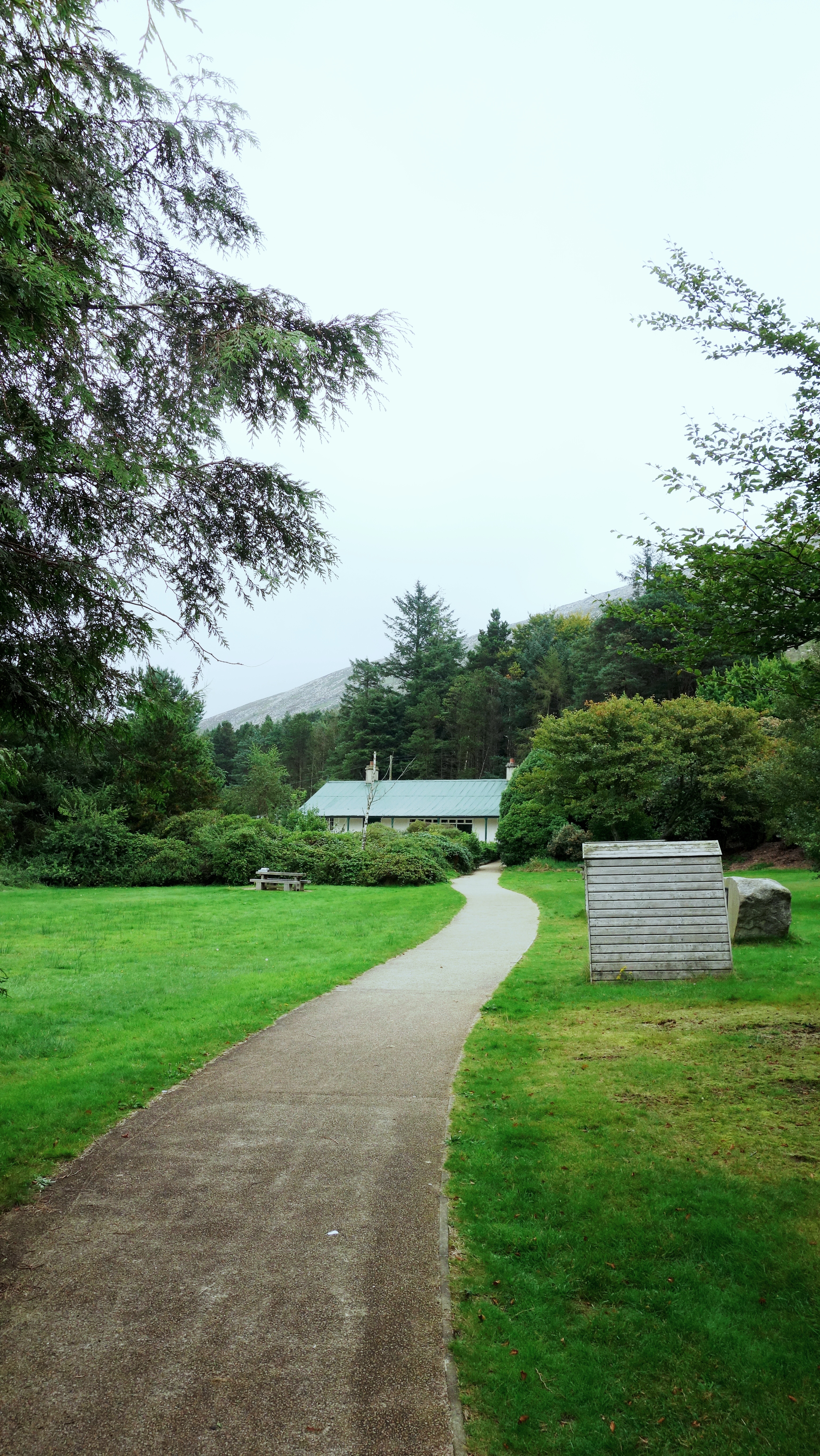
After parking your car (its £4.50 entrance fee for a car full of people at time of posting) you walk along the path before arriving at the information centre above. Nothing too impressive yet.

silent-valley-15

Some information on the dam. Apparently the valley used to be called Happy Valley but its not certain why the name was changed (one idea about this is on the sign above). It really is incredibly quiet up there though. Spot the 2 crane flies. 🙂

silent-valley-13

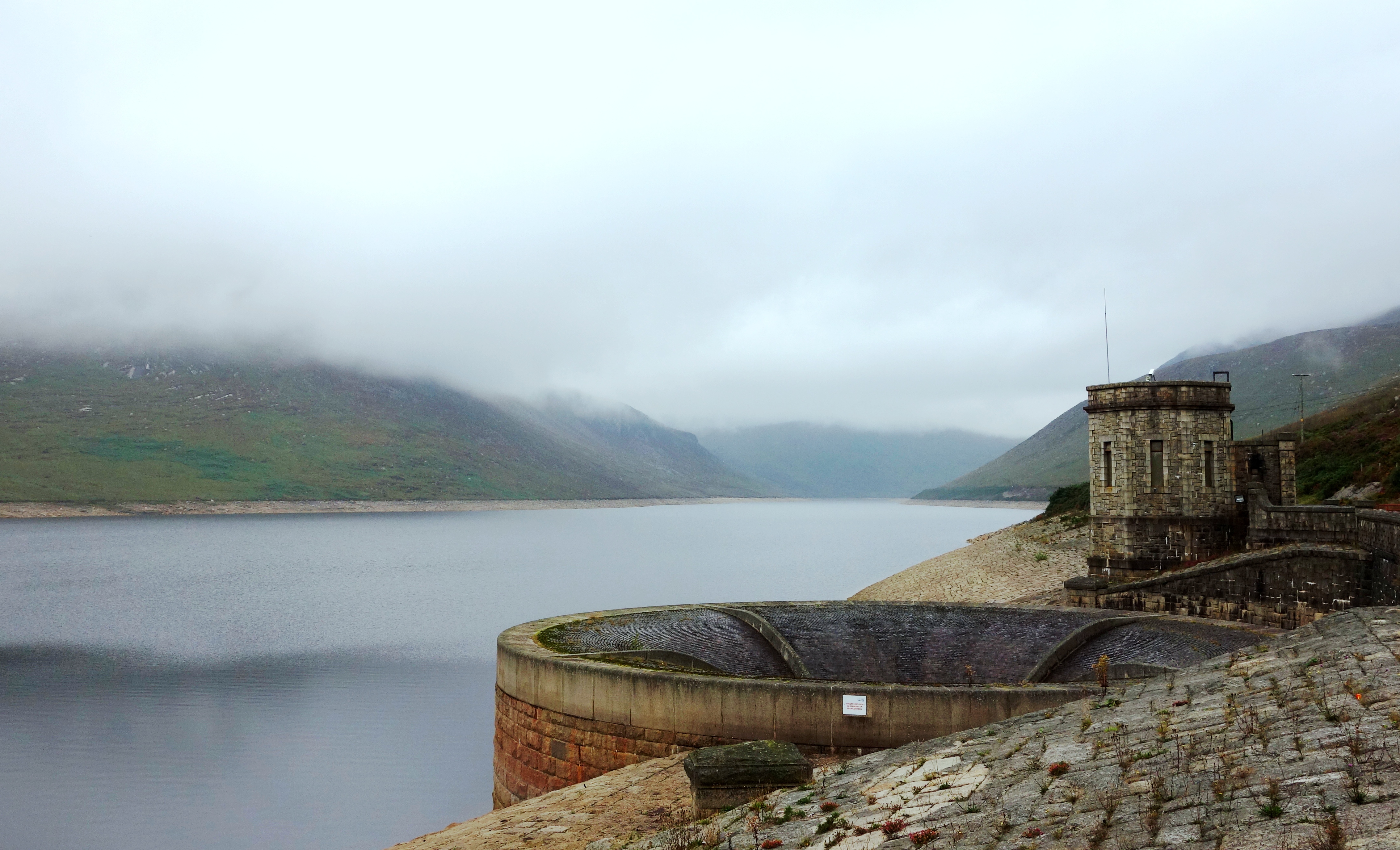
Your first view of the dam. The water was below the overflow level on the day I visited which drains excess water off via the circular construction thing you can see on the right of the picture. I’m not sure where the water goes when it disappears down the hole (maybe its how the devil gets his shower water) but if you want to see it in action there’s a small video here: https://www.youtube.com/watch?v=MxUEfQd4mk4

silent-valley-20 silent-valley-28

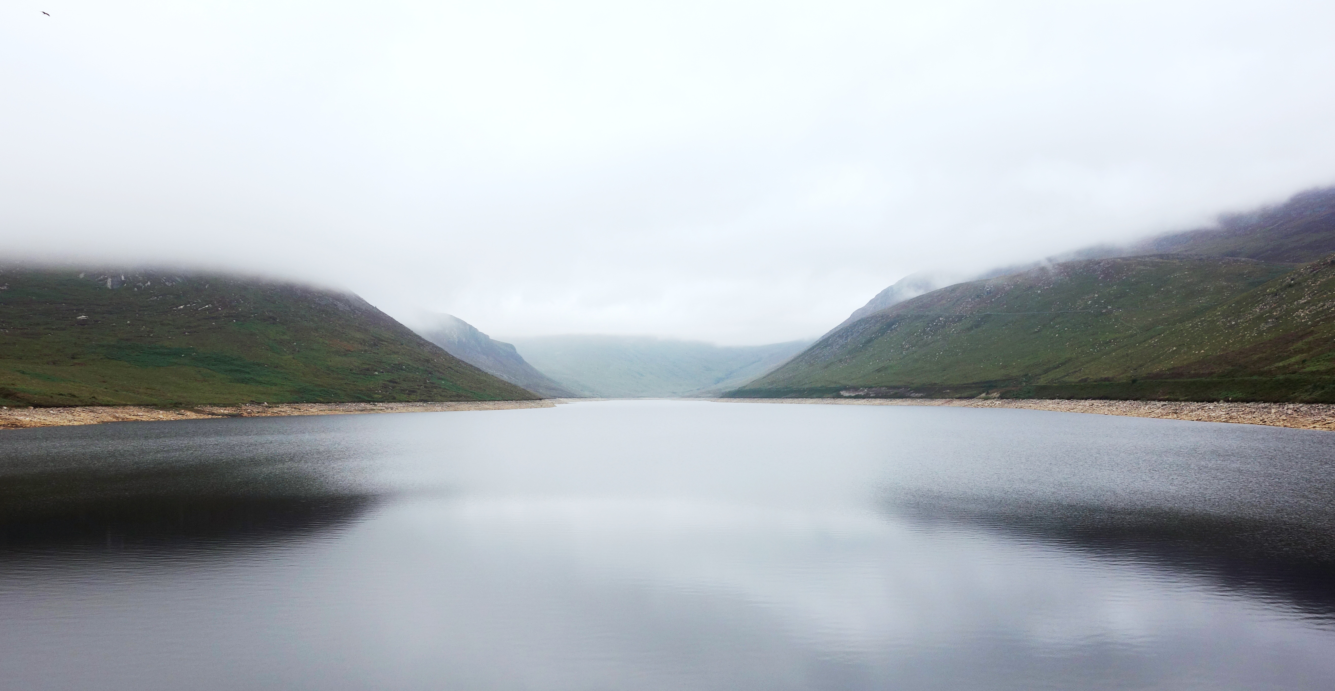
The first picture is looking up the reservoir from the walkway embankment. Even on an overcast day like this its still pretty impressive. The second picture is looking across from the left hand side of the water.

silent-valley-71

A little bit of back story about the men who built the dam. They even had their own workers village called “Watertown” and you can still see some of the old foundations of Watertown next to this sign.

silent-valley-46

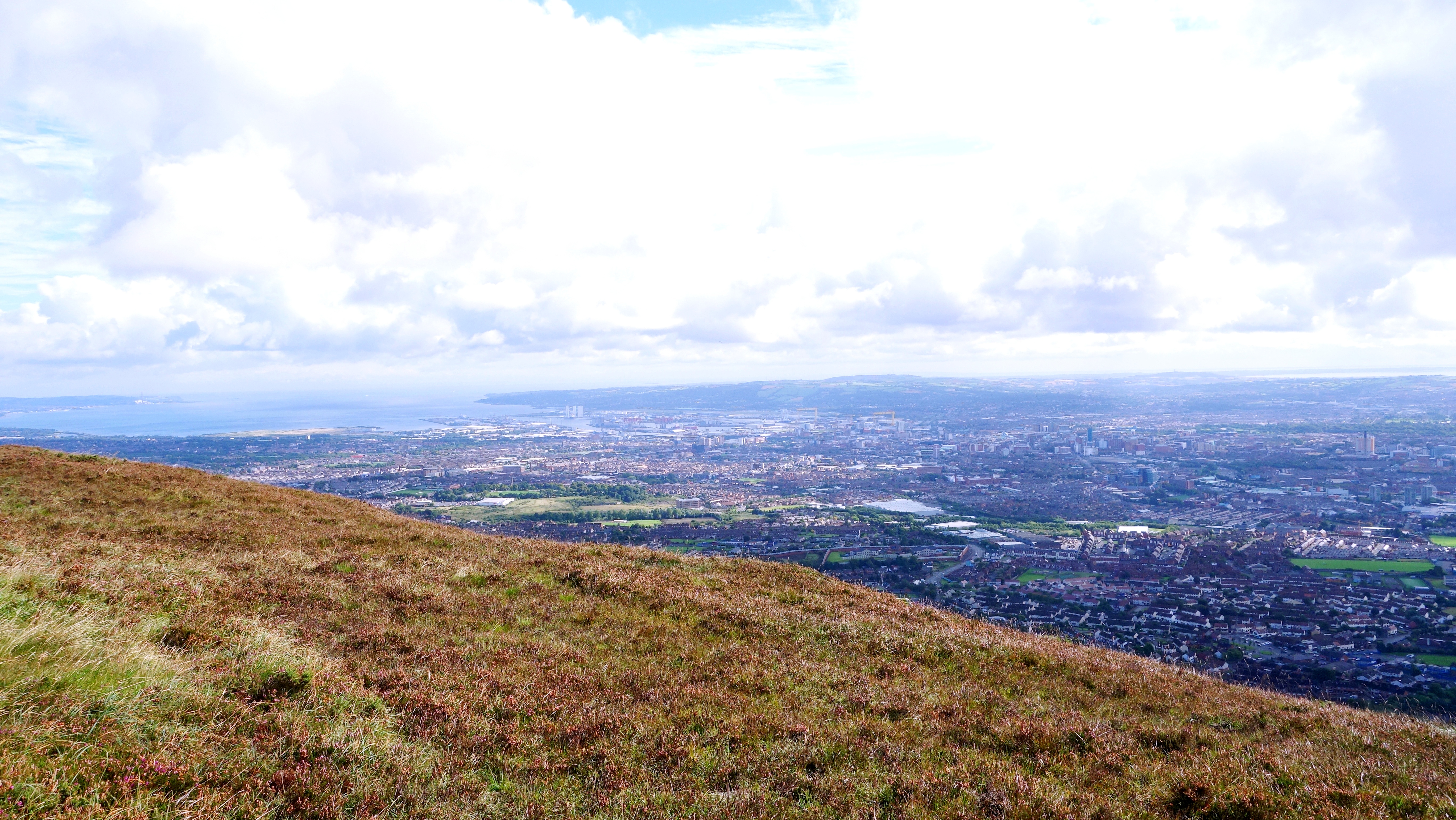
There are 5 walking routes around Silent Valley with one to suit every ability. I did the “Mountain Trail” (3.4km) route which is considered moderately difficult but it really wasn’t that bad. It gives good views over the reservoir from the left hand side of the water (as you come in). This picture was taken from near the top of the mountain trail.

silent-valley-58

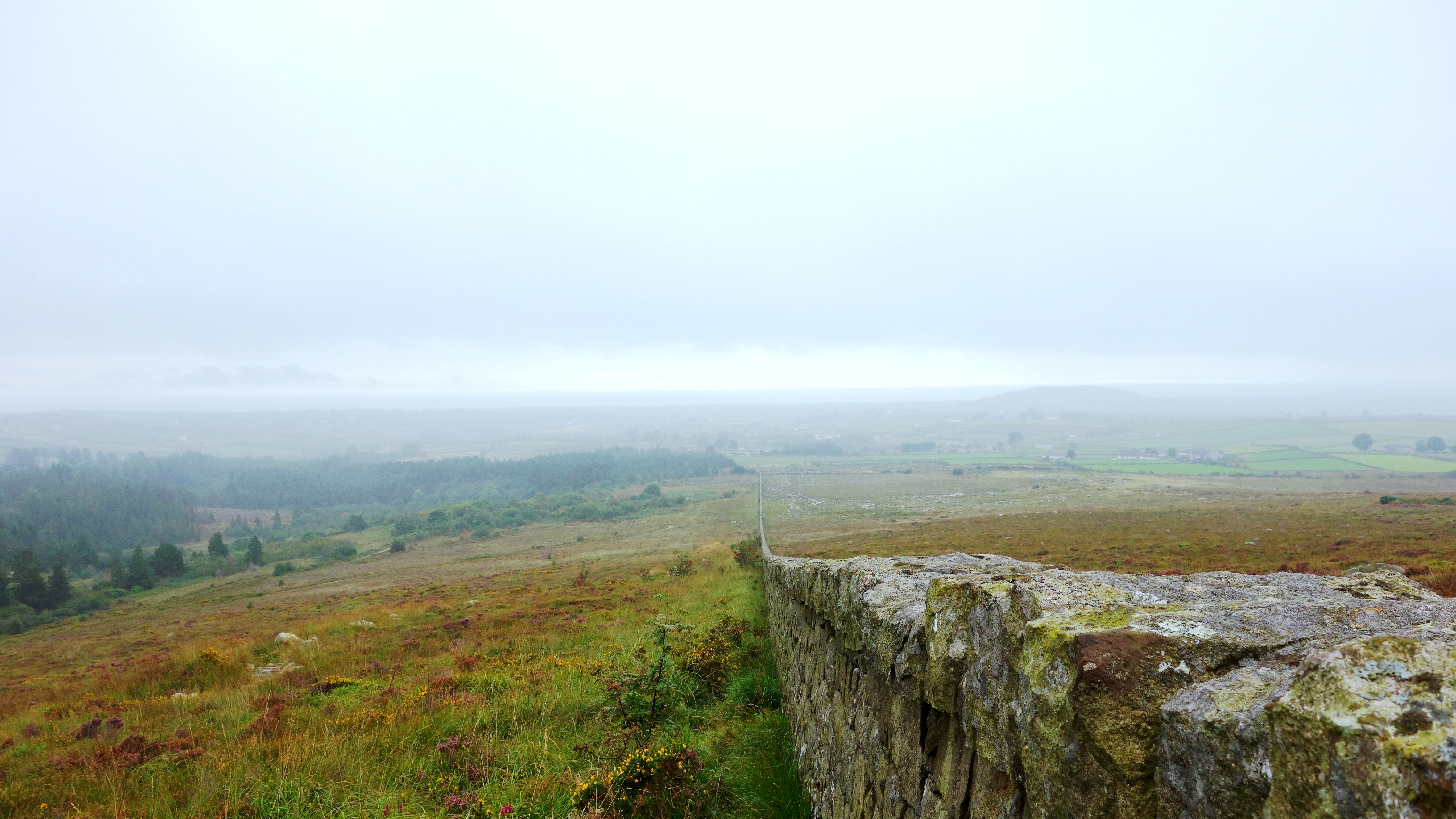
As you descend from the Silent Valley mountain trail you’ll reach the Mourne Wall which usually becomes a feature of many of the Mourne mountain range walks given its meandering 22 miles of length. Its always stunning to see it disappear off into the distance.

silent-valley-6

And finally, a little plaque in memory of the 8 men who died in construction of the dam (and one at Ben Crom dam too).

Titanic Belfast, Titanic Quarter & SS Nomadic

Once again Ive fallen a bit behind with posting a months pictures as work (and our new house needing decorating) just got in the way. Sadly my May 2016 post sunk into oblivion and never came to fruition but (again) I really want to get things back on track particularly now that I’m paying for the website (as my free WordPress allowance burst its seams with the amount of pictures Ive posted haha).

So talking of things that sunk (see what I did there?) its time for a visit to the hugely popular Titanic Centre area of Belfast although I didn’t actually visit any of the exhibitions there, I just wandered around outside snapping the vast area of land it covers. But it was a really enjoyable walk and it was totally free.


titanic (7)

The huge Titanic sign at the main entrance to the exhibition centre. There’s car parking below the centre that costs £1.50 per hour and there’s a cafe inside too if you just wanted to visit the area and pop in.


titanic (2)  titanic (6)

The June weather was wonderful on the day of my visit, and the Titanic building itself is pretty impressive dominating the skyline with every angle offering a different photo opportunity.

titanic (4)

Around the back of the Titanic building is Titanic Studios which used to be called the Paint Hall where all the components of the ships built here were painted and kept in climate controlled conditions. Today however, its actually much more interesting with the building becoming one of the biggest film studios in Europe, and being the filming location for movies and TV series such as City of Ember, Your Highness, Series 1 of Game of Thrones, and the very recent release of Ben Wheatleys “High Rise”.

titanic (5)

There are many signs and information boards around the area so you really don’t have to pay to see any of the exhibitions in the main building if you’re on a tight budget (and you can of course enter the building for free too).

titanic (14)

Please don’t climb up behind this lady whilst singing a Celine Dion song 🙂


titanic (12)

Across the road and facing the front of the Titanic Centre you can also visit the SS Nomadic which was tender to the Titanic and its also the last White Star Line surviving ship in the world.

titanic quarter (52)

The SS Nomadic has been fully restored and for less then £8 you can go on board and look around.

titanic (9)

titanic (13)

The Nomadic really has been restored to an excellent condition and looks fantastic sitting in the summer sunshine.

titanic (10)

Nomadic sitting on a shallow sea of algae. You can see how close it is to the Titanic building just to the left. Its a great little area for strolling around for a few hours for sure.

titanic (1)

And before I left I just had to snap one of these iconic yellow monsters piercing the blue sky of Belfast on such a lovely June day.

Bangor Castle, Bangor, County Down.

Bangor Castle was built for the Hon Robert Edward Ward and his family in 1852. It is presently the headquarters of North Down Borough Council who use the mansions spectacular grand salon as the council chamber. The building is situated in the grounds of Castle Park alongside North Down Museum and is just a short walk from Bangors Walled Garden.

DSC06998

The castle can be hired reasonably cheaply for wedding services and is a popular venue for those seeking a non-religious event.

DSC06985.JPG

Picture taken Christmas 2015 (spot the tree).

DSC06983 DSC06992

DSC06991

Bangor Castle overlooks the town of Bangor and its really worth having a walk around it and Castle Park behind. The walled garden (about ten minutes walk away) has just been used in the brand new film by Ben Wheatley called High Rise.


Craigmore Railway Viaduct, Newry

The Craigmore Viaduct (Irish: an Tarbhealach Craig Mór, meaning “the great rock trans-way”) is a railway bridge near Bessbrook, County Armagh, locally known as the 18 Arches. Near Newry railway station.

The bridge was designed by John Benjamin Macneill, an eminent Irish civil engineer, with construction beginning in 1849 for the Dublin and Belfast Junction Railway. The bridge was formally opened in 1852. It spans the valley of Camlough River. The viaduct consists of 18 arches of 60 ft span, the highest being 126 ft, making Craigmore the highest viaduct in Ireland. It is around a quarter of a mile long and was constructed from granite stone blocks from the nearby Goraghwood quarry near Goraghwood station, which for many years supplied ballast to the Dublin & Belfast Junction Railway’s lines.

craigmore (5)

A beautiful day underneath Craigmore

craigmore (1)

The Dublin-Belfast railway line crosses the bridge. From 1885 to 1948, the Bessbrook and Newry Tramway ran under the viaduct. On 2 March 1989, a Provisional Irish Republican Army bomb damaged Craigmore Viaduct, exploding just four minutes before a passenger train from Dublin was due to leave nearby Newry Station. A clearance operation had to be mounted and the railway line was closed and not reopened until 8 March 1989.

craigmore (3)